
Mull, Suie


Barrow (Prehistoric), Standing Stone(S) (Prehistoric)
Site Name Mull, Suie
Classification Barrow (Prehistoric), Standing Stone(S) (Prehistoric)
Alternative Name(s) Suidhe; Bunessan
Canmore ID 21762
Site Number NM32SE 7
NGR NM 3706 2185
Datum OSGB36 - NGR
Permalink http://canmore.org.uk/site/21762


- Council Argyll And Bute
- Parish Kilfinichen And Kilvickeon
- Former Region Strathclyde
- Former District Argyll And Bute
- Former County Argyll
NM32SE 7 3706 2185.
See also NM32SE 18.
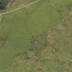
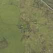
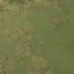
(NM 3706 2185) Cairn (NR)
OS 1:10,000 map, (1976)
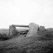
The turf-covered remains of a cairn; on its NNE side are two upright stones, and there is a curious arrangement of stones on its ESE edge. In the nearby ruined byre the stalls are formed with large flat slabs, possibly derived from the site. It seems likely that originally there was a cairn edged by a setting of tall upright stones, now almost entirely dismantled and re-used, but there is no evidence that the cairn was chambered.
E R Creegen 1958; A S Henshall 1972.
A cairn; the arrangement of stones on the ESE does not appear to be original. The southern of the two standing stones has a perforation on it; this is not a cup mark. The other stone, just outside the cairn edge, is probably unassociated, and may be a marker stone on the pilgrim route from Green Point to Iona.
Resurveyed at 1:2500.
Visited by OS (DWR) 22 April 1974.
Barrow and Standing Stones, Suie: Situated in moorland just S of the deserted township of Suie, there are the remains of a barrow and two standing stones. The barrow, now grass-covered, measures 22m by 19m, stands to a maximum height of about 1m, and is slightly hollowed at the centre; limited probing on the date of visit failed to reveal the presence of any stone in its make-up. On the E edge there is a polygonal setting of stones; measuring about 2m across internally, it has been lined by by a series of upright slabs, five of which are still in situ. Several other fallen slabs are visible, and one of them has been re-used to serve as a cover-slab or lintel. Without excavation it is impossible to interpret this setting, but there is nothing in its present appearance to suggest that is is the ruined chamber of a passage-grave. There are two standing stones on the NNE side of the barrow, one of them situated on the edge of the barrow itself; this stone measures 0.6m by 0.3m at its base and stands to a height of 1.1m. It is pierced by a hole some 20mm in diameter at a point 0.4m from the top of the N side, but this does not seem to be an ancient perforation. The other stone, now inclined to the NE, is 1.2m to the NE; straight-sided with a flat top, it measures about 0.6m by 0.3m at the base and 1.95m in height.
RCAHMS 1980, visited 1974.
Field Visit (23 June 1943)
This site was included within the RCAHMS Emergency Survey (1942-3), an unpublished rescue project. Site descriptions, organised by county, vary from short notes to lengthy and full descriptions and are available to view online with contemporary sketches and photographs. The original typescripts, manuscripts, notebooks and photographs can also be consulted in the RCAHMS Search Room.
Information from RCAHMS (GFG) 10 December 2014.
Field Visit (1991)
An area around this cairn and settlement NM32SE 18 was surveyed to confirm known details and to plot additional information. No new information was identified on the cairn, though the robbed out stone holes (possible) were located.
I Gray and E Gilfillan 1991.

