
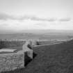
Lour House, The Temple


Folly (Period Unassigned)
Site Name Lour House, The Temple
Classification Folly (Period Unassigned)
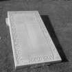
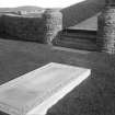
Alternative Name(s) Hill Of Lour; Lour House Policies; Francis Edward Carnegy Tombstone; Burial Ground
Canmore ID 216702
Site Number NO44NE 17.03
NGR NO 47216 46206
Datum OSGB36 - NGR
Permalink http://canmore.org.uk/site/216702


- Council Angus
- Parish Forfar
- Former Region Tayside
- Former District Angus
- Former County Angus
NMRS REFERENCE
Plans: I G Lindsay Collection, OJ/15 & W/304

