
Pricing Change
New pricing for orders of material from this site will come into place shortly. Charges for supply of digital images, digitisation on demand, prints and licensing will be altered.
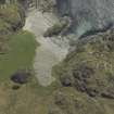
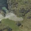
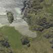
Iona, Port An Fhir-bhreige


Cairn(S) (Medieval)
Site Name Iona, Port An Fhir-bhreige
Classification Cairn(S) (Medieval)
Canmore ID 21640
Site Number NM22SE 31
NGR NM 2626 2187
NGR Description Centred on NM 2626 2187
Datum OSGB36 - NGR
Permalink http://canmore.org.uk/site/21640


- Council Argyll And Bute
- Parish Kilfinichen And Kilvickeon
- Former Region Strathclyde
- Former District Argyll And Bute
- Former County Argyll
NM22SE 31 2626 2187
(NM2626 2187) At least one large round cairn and many smaller mounds of stones lie on the old beach where there is a profusion of boulders. Tradition says they were erected by monks as a penance (Pennant 1774).
W Reeves 1857; O G S Crawford 1933; A Ritchie and E Ritchie 1934; T Pennant 1774; OS 6" map, annotated by O G S Crawford 16 August 1933.
A: NM 2626 2181; B: NM 2629 2191. Two large mounds of beach pebbles and several small piles of stone standing on the foreshore above high water mark. All appear to be artificially constructed, yet none has the appearance of age and their purpose is unknown. Mounds A and B are close enough to the sea to be destroyed by exceptionally high tides. Visited by OS (DWR) 8 June 1972.
Site recorded by AOC (Scotland) Ltd during an archaeological survey of the lands controlled by the National Trust for Scotland on Iona. This survey was conducted in late May and early April of 1996. The full report of this survey has been deposited with both the local SMR and the NMRS.
NM 2625 2185 Cairns
Sponsor: National Trust for Scotland
T Rees 1996
Aerial Photography (April 1969)
Oblique aerial photographs of sites and monuments on Iona, Argyll, photographed by John Dewar in 1969.
Field Visit (June 1979)
Cairns, Port an Fhir-bhréige, Iona (NM 262 219)
There are at least fifty cairns situated on the raised beach immediately N of Port an Fhir-bhréige. The majority of the cairns, which are composed of pebbles gathered from the raised beach, measure between 1m and 3m in diameter by 0.2m to 0.5m in height. Two, however, are considerably larger, measuring about 6m in diameter by 1.6m in height and surrounded by ditches 1m broad and 0.3m deep.
There is no reason to believe that these cairns are of prehistoric date, and in view of their situation on the pebble beach an agrarian origin also seems improbable. From the 18th century onwards they were noted by tourists who visited Columba's reputed landing-place at Port na Curaich, the adjacent bay to the E. Several visitors recorded the tradition that the cairns had been built as a penitential task imposed on pilgrims or monks, and Pennant added that, if the mounds were proportionate to their crimes, ‘it is no breach of charity to think them enormous sinners’ (1). They may indeed have been constructed as a devotional act by pilgrims, presumably during the medieval period.
RCAHMS 1982, visited June 1979.
(1) Pococke, Tours, 87; Irish Tourist, Iona, 17; Pennant, Tour (1772), I, 298, Garnett, Tour, 266.
Field Visit (April 1996 - May 1996)
Site recorded by AOC (Scotland) Ltd during an archaeological survey of the lands controlled by the National Trust for Scotland on Iona. This survey was conducted in late May and early April of 1996. The full report of this survey has been deposited with both the local SMR and the NMRS.
NM 2625 2185 Cairns
Sponsor: National Trust for Scotland
T Rees 1996
Field Visit (April 1996 - May 1996)
A series of at least fifty cairns constructed from beach cobbles lie upon an expanse of bare, raised beach behind Port na Fhir-bhéige. These cairns measure between 1.0 and 3.0m in diameter and between 0.2 and 0.5m in height. Two cairns are considerably larger at around 6.0m in diameter and 1.6m in height, surrounded by ditches 1.0m broad and 0.3m deep.
These cairns have traditionally been identified as the products of penitential tasks imposed on pilgrims or monks. The number and shape of the cairns appears to be the same on the 1946 aerial photographs which would suggest they are not a recent phenomenon.
(ION96 056)
Information from NTS (SCS) January 2016

