
Pricing Change
New pricing for orders of material from this site will come into place shortly. Charges for supply of digital images, digitisation on demand, prints and licensing will be altered.
Dalmellington, Mineral Railway


Railway (19th Century)
Site Name Dalmellington, Mineral Railway
Classification Railway (19th Century)
Canmore ID 216395
Site Number NS40NE 98
NGR NS 4750 0730
NGR Description NS 4500 0777 to NS 5000 0701
Datum OSGB36 - NGR
Permalink http://canmore.org.uk/site/216395


- Council East Ayrshire
- Parish Dalmellington
- Former Region Strathclyde
- Former District Cumnock And Doon Valley
- Former County Ayrshire
NS40NE 98 4750 0730, 4500 0777 to 5000 0701.
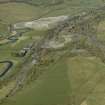
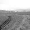
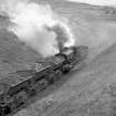
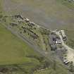
Field Visit (1 April 2016 - 30 June 2016)
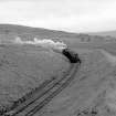
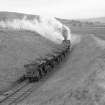
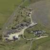
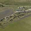
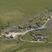
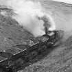
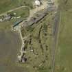
The mineral railway is depicted and annotated as such on the Ordnance Survey 2nd Edition map (1897). The railway is depicted and in use on aerial photographs dating to 1947 and 2000. Field survey recorded that the railway is still in use for coal transportation from NS 247360 607360 westwards. From NS 4736 0736 to NS 4856 0689, where it now ends, the railway is in use by the Ayrshire Railway Preservation Group.
Information from OASIS ID: waherita1-231107 (A Bicket) 2016

