
Pricing Change
New pricing for orders of material from this site will come into place shortly. Charges for supply of digital images, digitisation on demand, prints and licensing will be altered.
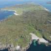
Iona, Port Na Curaich


Natural Feature(S) (Period Unassigned)
Site Name Iona, Port Na Curaich
Classification Natural Feature(S) (Period Unassigned)
Alternative Name(s) Columba's Bay
Canmore ID 21634
Site Number NM22SE 26
NGR NM 2634 2177
Datum OSGB36 - NGR
Permalink http://canmore.org.uk/site/21634


- Council Argyll And Bute
- Parish Kilfinichen And Kilvickeon
- Former Region Strathclyde
- Former District Argyll And Bute
- Former County Argyll
NM22SE 26 2634 2177
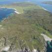
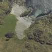
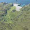
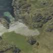
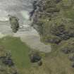
(NM 2628 2179) A mound, superficially comparable with Viking boat burials, composed of large beach pebbles, and measuring 33 paces by 8 paces, is situated on a storm beach within a few yards of H W M. The upcast beach pebbles seem to be advancing towards it and in August 1933 the bare beach was only 10 paces distant. The mound is well-preserved except at the west end where it has been slightly disturbed. Both the mound itself and the ground around are covered with a growth of fresh green grass, and there are signs of former cultivation. There is no trace of the two little stone pillars, one at each end, mentioned in the original record of the site where the mound is said to cover the boat or "curachan" in which Columba and his followers landed on Iona (Macfarlane 1906-8). The site is now known as "An Curachan", and a smaller mound is said to represent a boat being towed astern. "Port an Curaich" (NM 262 217) - "Bay of the Boat" - takes its name from the site.
O G S Crawford 1933; W Macfarlane 1906-8; D Wilson 1863; A Rithie and E Ritchie 1934.
NM 2634 2177: There is no evidence to suggest that this was a ship burial, and it is probably natural, possibly being an isolated stretch of storm bank.
Visited by OS (DWR) 3 June 1972.
This mound, which is grass-covered and aligned WNW and ESE, measures about 22m by 7.5m and is 0.6m high. Excavations in 1878 and 1897 revealed no evidence of artificial origin, and it is probably an isolated portion of storm-beach.
RCAHMS 1982, visited June 1979.
Site recorded by AOC (Scotland) Ltd during an archaeological survey of the lands controlled by the National Trust for Scotland on Iona. This survey was conducted in late May and early April of 1996. The full report of this survey has been deposited with both the local SMR and the NMRS.
NM 2635 2175 Mound
Sponsor: National Trust for Scotland
T Rees 1996.
Aerial Photography (April 1969)
Oblique aerial photographs of sites and monuments on Iona, Argyll, photographed by John Dewar in 1969.
Field Visit (June 1979)
‘Mound’, Port na Curaich, Iona (NM 263 217)
This small bay at the extreme S end of the island , whose name means ‘Harbour of the Curragh (skin-covered boat)’, and which is often referred to as 'St Columba's Bay', was traditionally identified as the landing-place of the saint on his arrival from Ireland. From the end of the 17th century onwards there are numerous accounts of visits by tourists who were taken there for that reason, and to collect the attractive pebbles of serpentine found on the beach, commonly known as 'Iona stones' or 'Iona pebbles' (1). Visitors were also shown a feature on the grassy area at the head of the bay, which was reputed to perpetuate the size and shape of the saint's boat. An account written before 1701 states that 'the length of this curachan or ship is … marked up at the head of the harbour upon the grass between two litle pillars of stons set up to shew forth ye samain (same), between which pillars there is three score of foots in lenth’ (2), and other 18th-century visitors also recorded the existence of two stones, or heaps of stones, which had disappeared by 1850 (3). Whereas some writers were unspecific about the nature of the intervening space, Martin describes it as 'a dock which was dug out' and a visitor in 1771 was shown a 'cavity' with 'massive stones erected at each end' (4).
Other writers, however, recorded 'an oblong heap of earth' , or 'an artificial mound, in the form of a boat with the keel up', which according to Graham had 'a little mound behind, representing the small boat which was towed astern' (5). This mound, which is grass-covered and aligned WNW and ESE, measures about 22m by 7.5m and is 0·6m high. Excavations in 1878 and 1897 revealed no evidence of artificial origin (6), and it is probably an isolated portion of storm-beach.
RCAHMS 1982, visited June 1979
(1) Sacheverell , Voyage, 143; Geog. Coll., 2, 217, 219 ; Martin, Western Islands, 291; Sharp, LW (ed.), Early Letters of Robert Wodrow, SHS (1937), 162 , 226; Irish Tourist, Iona, 17; Pennant, Tour (1772), 1,298; Boswell, Tour, 338; Clarke, 'Journal', 318; Murray, Guide, 2, 44, 212. Douglas's Map of 1769 marks 'Portichury, Remarkable for Pebles'.
(2) Nat. Lib of Scot. , Wodrow Letters, Quarto, vol. ii (unpaginated) , quoted in Maidment, J (ed.), Analecta Scotica, 1, 115; NSA, 7 (Argyll), 316; Adamnan, Columba (Skene), p. cxli, and Antiquity, 7 (l933), 454.Pococke, Tours, 87; Irish Tourist, Iona, 16; Boswell , Tour, 338; Graham , Iona, 5.
(3) Martin, Western Islands, 291; Irish Tourist, Iona, 16.
(4) Pennant, Tour (1772),1, 298; Stat. Acct., 14 (1795), 203; Garnett, Tour, 1, 266; Graham, Iona, 5 and pl. iii.
(5) Scottish Geographical Magazine, 3 (1887), 82- 3; MacMillan, Iona, 90.
Field Visit (April 1996 - May 1996)
Site recorded by AOC (Scotland) Ltd during an archaeological survey of the lands controlled by the National Trust for Scotland on Iona. This survey was conducted in late May and early April of 1996. The full report of this survey has been deposited with both the local SMR and the NMRS.
NM 2635 2175 Mound
Sponsor: National Trust for Scotland
T Rees 1996.
Field Visit (April 1996 - May 1996)
A grass covered mound, measuring 22.0m by 7.5m and 0.6m high, lies immediately behind the storm beach of Port na Curaich. It is composed of beach pebbles and is aligned east to west.
Traditionally this mound was said to have been raised over the coracle in which Collum Cille travelled to Iona. However excavations in 1878 and 1897 suggested it to be an isolated fragment of the storm beach.
The bay's name translates as Harbour of the Curagh or St Columba's Bay, traditionally identified as the landing place of St Columba on his arrival from Ireland. From the 17th century there are numerous accounts of visits by tourists.
(ION96 057)
Information from NTS (SCS) January 2016

