
Pricing Change
New pricing for orders of material from this site will come into place shortly. Charges for supply of digital images, digitisation on demand, prints and licensing will be altered.
Iona, Garadh Eachain Oig


Township (Post Medieval)
Site Name Iona, Garadh Eachain Oig
Classification Township (Post Medieval)
Alternative Name(s) Staoineig
Canmore ID 21633
Site Number NM22SE 25
NGR NM 2642 2221
NGR Description Centred on NM 264 221
Datum OSGB36 - NGR
Permalink http://canmore.org.uk/site/21633


- Council Argyll And Bute
- Parish Kilfinichen And Kilvickeon
- Former Region Strathclyde
- Former District Argyll And Bute
- Former County Argyll
NM22SE 25 264 221
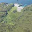
(Area: NM 264 221) Garadh Eachain Oig: "the Garden of the Young Hector": the remains of a settlement, including houses, enclosures, and traces of cultivation.
The remains of houses are especially numerous on the E side of the valley, near the stream which runs down from Loch Staonaig (NM 266 225). The name of the settlement is said to have come from Hector MacLean, one of the Duart family, traces of whose house were said to be visible at the head of Port na Curaich (NM 262 217) in 1857, where a small hamlet was extant in 1815.
W Reeves 1857; O G S Crawford 1933; A Ritchie and E Ritchie 1934.
A depopulated settlement consisting of about three roofless buildings and other enclosures.
Visited by OS (DWR) 8 June 1972
Visible on RAF air photograph 106G/Scot/UK35: 5100, 27 April 1946.
Site recorded by AOC (Scotland) Ltd during an archaeological survey of the lands controlled by the National Trust for Scotland on Iona. This survey was conducted in late May and early April of 1996. The full report of this survey has been deposited with both the local SMR and the NMRS.
NM 2646 2214 Settlement and banks
Sponsor: National Trust for Scotland
T Rees 1996
Field Visit (June 1979)
Garadh Eachain Òig.
The buildings are situated on natural terraces at the NE side of the valley, one group being on the NW bank of a small stream which flows SW from Loch Staoineig to Port an Fhir-bhreige, and the other about 100m to the S. Both structures in the former group (A, B) and the principal one in the latter group (C) are of sub-rectangular plan, with rounded internal and external angles. They measure respectively 11.4m, 9m and 6·5m in length, and vary in width from 3m to 3·5m, within dry-stone walls from 1 m to 1·4 m thick which survive to a maximum height of 0.8m. Although their walls are much ruined in places, all three buildings appear to have had opposed openings in the sidewalls, varying from 0.6m to 1 m in width. Building A stands upon an artificially revetted platform and B, on a higher terrace, has a small turf-walled enclosure attached to its NW gable. Close to building C there is a structure (D) measuring about 4m square within 1.2m walls, and another (E) of indeterminate plan. A small shed or store (F), measuring 2·5m by 2m within 0.7m walls, is situated among rocks about 55 m w of building A.
Buildings A and B stand in the SE part of a squarish turf-walled enclosure measuring about 2.3ha (5.7acres) in extent, identifiable on Douglas's estate-map of 1769. The SW dyke of this enclosure passes about 10m SW of building F, and after crossing the stream curves to meet a D-shaped stone-walled enclosure (G) about 20m in length, also shown on Douglas's Map, located at the foot of the rocky knoll on which stand buildings C, D and E. These enclosures were presumably connected with stock-rearing; the larger one, which contains much rough ground, is identified by Douglas as 'green pasture', although there are a clearance-cairn and traces of cultivation-rigs in the valley between buildings A and F. A small series of lazy-beds is set on level ground SE of building e, and similar ridges occur in a minor valley to the NE, bounded on the E by a curving turf dyke which is indicated on Douglas's Map and appears to be the E boundary of the large enclosure described above.
The estate-map of 1769, as well as showing the principal enclosures in this area, identifies a 'house' whose position and alignment correspond with those of building B, and an 18th-century date seems probable for all the extant buildings. Local tradition in the 19th century identified the Hector Og of the place-name as a cadet of the family of MacLean of Duart, and another MacLean, one of the tenants or sub-tenants of the island, who was involved in the Jacobite rising of 1745, was said to have lived at this settlement (1). Douglas's explicit statement in 1769 about the disuse of the arable ground N of Port na Curaich (supra) is consistent with Boswell's observation, four years later, that only a few cowherds lived outside the area of the village (2), and the settlement may have reverted to its original dependent pastoral status after a period of mixed cultivation under a tenant-farmer. It is reputed to have been occupied at the time of the Battle of Waterloo (1815), but was evidently abandoned some considerable time before the middle of the 19th century (3).
RCAHMS 1982, visited June 1979
(1) Adamnan, Columba (Reeves), 422; Campbell, Lord A, Records of Argyll (1885), 363. But Campbell's account probably refers to the tacksman John MacLean , who almost certainly lived in the village area (pp. 8 and 265, nn. 16, 17).
(2) Boswell , Tour, 330.
(3) Ritchie, Iona, 15; Adamnan, Columba (Reeves), 422.
Field Visit (April 1996 - May 1996)
Site recorded by AOC (Scotland) Ltd during an archaeological survey of the lands controlled by the National Trust for Scotland on Iona. This survey was conducted in late May and early April of 1996. The full report of this survey has been deposited with both the local SMR and the NMRS.
NM 2646 2214 Settlement and banks
Sponsor: National Trust for Scotland
T Rees 1996
Field Visit (April 1996 - May 1996)
A group of six structures with an associated field system lie to the south of Loch Staoineig. Three of the structures are substantial rectangular buildings all with two opposed entrances, ranging in length from 8. 5m to 13.5 m, with a common width of circa 5.0 m. The other three structures are smaller square or sub-circular structures, between 3.0m and 6. 0m in length. A number of small enclosures are appended to, or in close proximity to, the structures. A larger field system runs away to the north with the walls up to 1.5m high and 2.0m broad. This site is heather covered.
This settlement, known as Garadh Eachain Oig (the enclosure of Hector Og) is commonly linked with the period when the Maclean of Duart controlled the island. Abandoned around the mid-19th century.
(ION96 051)
Information from NTS (SCS) January 2016

