
Glenluce, North Street, Station


Railway Station (19th Century) - (20th Century)
Site Name Glenluce, North Street, Station
Classification Railway Station (19th Century) - (20th Century)
Alternative Name(s) Glenluce Station
Canmore ID 216227
Site Number NX15NE 135
NGR NX 19928 57647
Datum OSGB36 - NGR
Permalink http://canmore.org.uk/site/216227

- Council Dumfries And Galloway
- Parish Old Luce
- Former Region Dumfries And Galloway
- Former District Wigtown
- Former County Wigtownshire
NX15NE 135 19928 57647
For bridge carrying North Street across the railway at NX 19961 57689 (within the confines of this station), see NX15NE 123.
This station is depicted on the OS 1:2500 map of 1895 (Wigtownshire Sheet 19) and is no longer in use.
Information from RCAHMS (SC), May 2002.
This intermediate station on the Castle Douglas - Stranraer (Challoch Junction) portion (forming the Portpatrick and Wigtownshire Joint Rly) of the Dumfries - Stranraer 'Port Road' was opened (by the Portpatrick Rly) on 12 March 1861. It closed to regular passenger traffic (with the line as a whole) on 14 June 1965.
The current edition of the OS (GIS) MasterMap indicates the outline of the greater part of this station, but does not identify it as such.
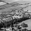
The station is situated within the N side of Glenluce village (NX15NE 52).
Information from RCAHMS (RJCM), 29 July 2009.

