
Pricing Change
New pricing for orders of material from this site will come into place shortly. Charges for supply of digital images, digitisation on demand, prints and licensing will be altered.
Upcoming Maintenance
Please be advised that this website will undergo scheduled maintenance on the following dates:
Thursday, 9 January: 11:00 AM - 3:00 PM
Thursday, 23 January: 11:00 AM - 3:00 PM
Thursday, 30 January: 11:00 AM - 3:00 PM
During these times, some functionality such as image purchasing may be temporarily unavailable. We apologise for any inconvenience this may cause.
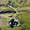
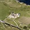
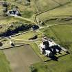
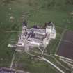
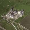
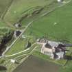
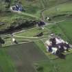
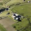
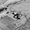
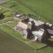
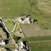
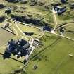
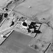
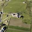
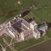
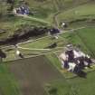
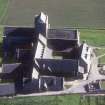
Iona, St Mary's Chapel


Chapel (Medieval)
Site Name Iona, St Mary's Chapel
Classification Chapel (Medieval)
Alternative Name(s) Caibeal Muire
Canmore ID 21619
Site Number NM22SE 12
NGR NM 28700 24424
Datum OSGB36 - NGR
Permalink http://canmore.org.uk/site/21619


- Council Argyll And Bute
- Parish Kilfinichen And Kilvickeon
- Former Region Strathclyde
- Former District Argyll And Bute
- Former County Argyll
NM22SE 12 28700 24424
(NM 2870 2441) St Mary's Chapel (NR)
OS 6" map, Argyllshire, 2nd ed., (1900)
'Caibeal Muire', Mary's Chapel is in ruins, its gables having fallen, but it appears to have measured about 30' by 16'.
The interior was being used for burial in the mid-18th century, and several uninscribed tomb-stones have been found in it.
W Reeves 1857.
Generally as described.
Revised at 1/2500.
Visited by OS (RD) 9 June 1972.
Site recorded by AOC (Scotland) Ltd during an archaeological survey of the lands controlled by the National Trust for Scotland on Iona. This survey was conducted in late May and early April of 1996. The full report of this survey has been deposited with both the local SMR and the NMRS.
NM 2870 2441 Chapel
Sponsor: National Trust for Scotland
T Rees 1996
Field Visit (August 1974)
St Mary's Chapel, Iona.
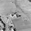
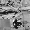
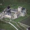
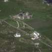
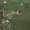
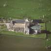
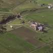
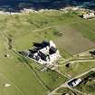
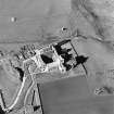
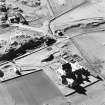
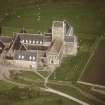
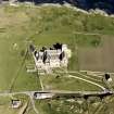
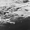
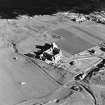
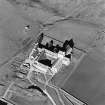
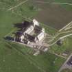
The fragmentary remains of this medieval chapel are situated in arable land some 60m s of the E end of the abbey church. No references to it have been identified before the second half of the 18th century, when it is mentioned by Walker and Pennant. Such architectural details as are known suggest that it was built some time after the foundation of the Benedictine abbey, but its function in relation to the latter is uncertain. Douglas's Map of Iona, surveyed in 1769, shows that one branch of the medieval causeway that led N from the Nunnery past MacLean's Cross swung E to pass the W end of the chapel before terminating at the SE angle of the abbey enclosure. This may suggest that the chapel was regularly visited by medieval pilgrims to Iona, rather than being reserved for the private use of the monastic community. Although Walker states that it was used as a burial-place for men, and Reeves records the discovery of several uninscribed tombstones within the chapel, these cannot now be identified.
All that is now visible of the structure is part of the N wall, standing to a height of about 2·8m and measuring about 8·5m in length and 0·9m in thickness, and a corresponding section of the s wall, greatly decayed on the outer face. The masonry is of granite rubble, well coursed and bonded with rough lime-mortar. The interior and immediate surroundings of the chapel are now encumbered with debris to a depth of at least 0·9m above the original level. Complete clearance of the foundations, carried out in 1874-5 under the direction of R Rowand Anderson, was recorded by Sir Henry Dryden in drawings which have been utilised for the accompanying figures. His survey shows that the building measured 16m by 4.7m internally, the walls at each end surviving to an average height of 0.4m above a flat foundation-course. A break in the upstanding portion of the N wall, some 6·1 m E of the NW angle, marks the position of a doorway with three orders of roll-moulded jambs rising from a chamfered plinth; the diameter of the rolls of the two outer orders was 0.09m, and that of the quirked inner order 0·07m. This doorway was similar in composition to, but slighter than that of the 'Michael Chapel'; in conjunction with the elongated ground-plan, it suggests a13th-century date of construction. The orientation of the chapel, like several other peripheral buildings at Iona, is much closer to true E than is the abbey church, the deflection in this case being some three degrees S of E.
RCAHMS 1982, visited August 1974
Field Visit (April 1996 - May 1996)
Site recorded by AOC (Scotland) Ltd during an archaeological survey of the lands controlled by the National Trust for Scotland on Iona. This survey was conducted in late May and early April of 1996. The full report of this survey has been deposited with both the local SMR and the NMRS.
NM 2870 2441 Chapel
Sponsor: National Trust for Scotland
T Rees 1996
Field Visit (April 1996 - May 1996)
St Mary's Chapel is in ruins, its gables and the exterior face of the side walls having fallen. The surviving side walls stand almost to roof height. The interior measures approximately 10.0m by 5.3 m.
The Chapel may originate in the thirteenth century. The interior was used for burial during the mid-eighteenth century and in 1875 AD it was cleared and recorded as 18.0m long with a doorway at the north (RCAHMS 1982).
(ION96 026)
Information from NTS (SCS) January 2016
External Reference (28 October 2011)
Scheduled as element within 'The monument known as St Mary's Abbey, Iona, monastic settlement [comprising] the remains of the large early historic monastic settlement founded by St Columba in AD 563, St Martin's Cross, and parts of medieval buildings associated with the Benedictine Abbey of St Mary founded around AD 1200.'
Information from Historic Scotland, scheduling document dated 28 October 2011.

