
Following the launch of trove.scot in February 2025 we are now planning the retiral of some of our webservices. Canmore will be switched off on 24th June 2025. Information about the closure can be found on the HES website: Retiral of HES web services | Historic Environment Scotland
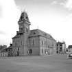
Wigtown, The Square, County Buildings


County Building (19th Century), Court House (19th Century), Town Hall (19th Century), Town Hall (18th Century), War Memorial (20th Century)
Site Name Wigtown, The Square, County Buildings
Classification County Building (19th Century), Court House (19th Century), Town Hall (19th Century), Town Hall (18th Century), War Memorial (20th Century)
Alternative Name(s) Bank Street; South Main Street; Town Hall
Canmore ID 215461
Site Number NX45NW 107
NGR NX 43425 55374
Datum OSGB36 - NGR
Permalink http://canmore.org.uk/site/215461


- Council Dumfries And Galloway
- Parish Wigtown
- Former Region Dumfries And Galloway
- Former District Wigtown
- Former County Wigtownshire
NX45NW 107 43425 55374
County Buildings [NAT]
OS (GIS) MasterMap, July 2009.
NMRS REFERENCE
Architect: Messrs Wardrop 1862-3
replacing old sym. Classical Building of c.1756
(Undated) information in NMRS.
Publication Account (1981)
An early reference to a tolbooth in Wigtown occurs in 1591, and it is possible that this structure was blown up by gunpowder in the eighteenth century to make way for the Market (or Court) House mentioned by Bishop Pococke in 1760 and another eighteenth-century writer, Samuel Robinson (Fraser, 1877, 32; Kemp, 1887, 18; Fraser, 1877, 32). This municipal building is its turn gave way to the County Buildings which were erected in 1862.
Information from ‘Historic Wigtown: The Archaeological Implications of Development’ (1981).

