
Tiree, Dun Beag, Vaul


Dun (Period Unassigned)
Site Name Tiree, Dun Beag, Vaul
Classification Dun (Period Unassigned)
Canmore ID 21527
Site Number NM04NW 4
NGR NM 0463 4926
Datum OSGB36 - NGR
Permalink http://canmore.org.uk/site/21527


- Council Argyll And Bute
- Parish Tiree
- Former Region Strathclyde
- Former District Argyll And Bute
- Former County Argyll
NM04NW 4 0463 4926.
(NM 0463 4926) Dun Beag (NAT) Fort (NR)
OS 1:10,000 map, (1976)
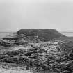
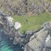
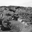
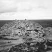
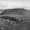
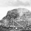
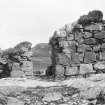
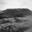
Dun Beg, Vaul, is a roughly oval fort whose outline is dictated by the shape of the rocky knoll on which it stands. No structural features apart from low wall-faces are visible. A trial trench was put into the edge of the flat summit to secure a sample of artifacts. A midden deposit of bones, many sherds, and a complete ring-headed pin were found. This deposite was just below the turf and lying on top of the ruined wall. The sherds bear incised patterns and are comparable to those found in Hebridean wheel-houses.
E W MacKie 1963; E Beveridge 1903.
Revised at 1:10560 scale.
Visited by OS (R D) 23 June 1972.
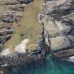
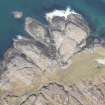
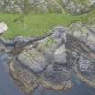
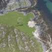
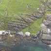
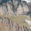
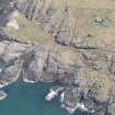
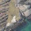
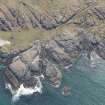
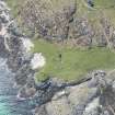
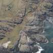
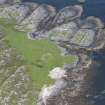
Dun, Dun Beag, Vaul: The remains of this dun and its out-work are situated on the summit of a prominent rocky knoll on the seashore about 250m N of Vaul village. On the SW (landward) side, where the approach
is relatively easy, the knoll rises to a height of 5m above the level
of the adjacent ground, but elsewhere precipitous rocky cliffs afford considerable natural protection.
Roughly oval on plan, the dun measures about 22.5m by 15m within the ruins of a dry-stone wall, which survives as a grass-grown band of debris 5m in greatest thickness. No inner facing-stones are now visible, but the line of the outer face can still be traced round most of the perimeter at a depth of at least 3m below the present ground-level inside the dun. The entrance is situated on the W, and a few facing-stones of each passage-wall survive, indicating that its width at the inner end was about 1.9m. The relative positions of the two surviving stones of the S wall suggest that it was checked for a door about half-way along the passage. Within the body of the wall immediately N of the entrance there appears to be a built face running at right angles to the passage, which may possibly form part of an internal stabilising revetment. The interior of the dun, which is comparatively level and grass-covered, contains a number of secondary structures. The largest, a ruinous sub-circular stone-and-turf enclosure of no great age, has encroached upon the inner part of the dun wall on the S. The others, which may be of even later date, appear as small sub-oval or sub-rectangular depressions about 0.4m deep; one lies within the enclosure just described, and another partially overlies the ruins of the dun wall to the N of the entrance.
At the foot of the knoll on the SW there are traces of an outer wall, presumably designed to restrict access to the dun on its more vulnerable side. It has been reduced to an intermittent scatter of stony debris in which several outer facing-stones have survived in position. The entrance was probably situated at the foot of the path that leads obliquely up the side of the knoll.
RCAHMS 1980, visited 1974.
Publication Account (2007)
NM04 5 DUN BEAG, VAUL
NM/0463 4926
This site is likely to be an oval dun rather than a broch [3, fig. 116] but is mentioned here because of the finds made in a limited trial excavation in 1963 [2]. The ruins stand on a rock knoll about 400m east of the broch Dun Mor Vaul (NM04 4). A trial trench on the summit of the knoll showed that the ruins of the main wall were overlaid by occupation debris which yielded decorated pottery indistinguishable from that found at Dun Mor Vaul as well as a complete bronze ring-headed pin. The finds are kept in the Hunterian Museum of the University of Glasgow. This evidence probably provides further confirmation that different kinds of Iron Age stone structure need not imply major cultural differences; pottery and artifacts are the best guide to these, or to their absence.
Sources: 1. NMRS site no. NM 04 NW 4: 2. E W MacKie in Discovery and Excavation in Scotland 1963, 20-1: 3. RCAHMS 1980, no. 196, 104-05.
E W MacKie 2007

