
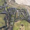
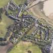
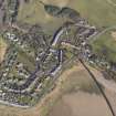
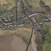
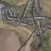
Powfoot, Powfoot Bridge


Road Bridge (Period Unassigned), Wall(S) (Period Unassigned)
Site Name Powfoot, Powfoot Bridge
Classification Road Bridge (Period Unassigned), Wall(S) (Period Unassigned)
Alternative Name(s) Pow Water; Powfoot Bridge And Retaining Walls
Canmore ID 214901
Site Number NY16NW 93
NGR NY 14947 65776
Datum OSGB36 - NGR
Permalink http://canmore.org.uk/site/214901


- Council Dumfries And Galloway
- Parish Cummertrees
- Former Region Dumfries And Galloway
- Former District Annandale And Eskdale
- Former County Dumfries-shire
NY16NW 93 14947 65776
Powfoot Bridge [NAT]
OS (GIS) MasterMap, August 2009.
This bridge carries an unclassified public road over the Pow Water within the area of Powfoot village.
Information from RCAHMS (RJCM), 12 August 2009.

