
Tiree, Eilean Na Ba


Fort (Period Unassigned)
Site Name Tiree, Eilean Na Ba
Classification Fort (Period Unassigned)
Alternative Name(s) Beinn Ceann A' Mhara; Rinn Thorbais
Canmore ID 21481
Site Number NL94SW 6
NGR NL 9336 4006
Datum OSGB36 - NGR
Permalink http://canmore.org.uk/site/21481


- Council Argyll And Bute
- Parish Tiree
- Former Region Strathclyde
- Former District Argyll And Bute
- Former County Argyll
NL94SW 6 9336 4006.
(NL 9336 4006) Fort (NR) (rems of)
OS 1:10,000map, (1976)
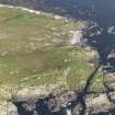
Fort, Eilean na Ba: This fort occupies a rocky promontory separated from Beinn Ceann a' Mhara by a gorge 16.5m deep. The landward side is defended by a single stone wall which has been reduced to a low stony mound 1m in average thickness; no inner facing-stones are visible but there are several short stretches of outer face. On the seaward side the defences have been limited to two short stretches of walling on the SE (B and C), blocking gullies that could be approached from the sea.
Only a small proportion of the area enclosed is suitable for habitation, much of the interior consisting of jagged rock-sheets; but from the highest point of the fort, on the NW, the ground slopes south-eastwards in a series of turf-covered shelves, and on the first of these there are the traces, now too indefinite to plan, of what may have been at least two circular stone-walled houses. The entrance to the fort lay on the E where the cliff is interrupted by a gully. The approach has been improved by steps cut in the gully floor, and by a stone-revetted causeway (D) which leads across the gorge from the base of the steps.
RCAHMS 1980, visited 1975; E Beveridge 1903
Surveyed at 1:10,560.
Visited by OS (D W R) 26 June 1972.
Note (5 November 2014 - 23 May 2016)
This fort occupies a headland cut off on the landward side by a chasm over 15m deep. Irregular on plan, the full extent of the interior is unclear, its defences comprising a single wall extending along the lip of the chasm on the landward, NE, side, and two short lengths of wall blocking off gullies that drop down to the sea on the S, though not one giving access into a tidal gully on the W, which cuts through the promontory from N to S and divides it into two discreet areas. In the plan and description published in the County Inventory for Argyll (RCAHMS 1980, 83, no.145, fig 70), the seaward half is discounted, extending to some 0.47ha of rough and exposed outcrops with grassy ledges, but the only possible access to it from the land must pass through the defences on the NE. These enclose a further 0.6ha, much of which is equally bleak bare outcrop. Nevertheless, traces of the stone footings of two round-houses were noted on a terrace on the NW. The entrance to the fort lies on the E, where a stone-revetted causeway crosses the bottom of the chasm, leading to steps cut in the floor of a gully that obliquely mounts the rock face to give access into the interior.
Information from An Atlas of Hillforts of Great Britain and Ireland – 23 May 2016. Atlas of Hillforts SC2487

