
House Of The Binns, Walled Garden


Walled Garden (Period Unassigned)
Site Name House Of The Binns, Walled Garden
Classification Walled Garden (Period Unassigned)
Alternative Name(s) Kitchen Garden; Binns Policies
Canmore ID 213991
Site Number NT07NE 4.04
NGR NT 05171 78318
Datum OSGB36 - NGR
Permalink http://canmore.org.uk/site/213991


- Council West Lothian
- Parish Abercorn (West Lothian)
- Former Region Lothian
- Former District West Lothian
- Former County West Lothian
NT07NE 4.04 01571 78318
Reference (March 2013)
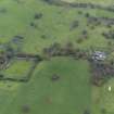
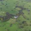
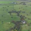
An trapezoidal walled enclosure measuring (at the mid point) 95m (E-W) by 75m (N-S) on a south-facing slope with the north wall running due east-west. On the inner face the wall is built with a rubble stone lower half and brick upper half on the west, north and east sides, with the south wall entirely in brick. On the outside face the west, north and east sides are entirely in rubble stone, with the south wall again entirely in brick although rendered at the former conservatory. The south wall rises in height in an 18m central section and all the wall is topped by a stone flag cope. Foot-gates are positioned near the north end of the west wall, the north end of the east wall (blocked up) and the west end of the south wall, with a double-leaf vehicle gate (angle iron and weld-mesh) added in recent times near the east end of the south wall. A row of bothies lie along the inner face of the south wall, with evidence of a conservatory on the outer face. In the north-west corner an area is divided off from the main garden by a low brick wall c1.2m high with brick piers every 2.0m. A small shed with a tall brick chimney lie in the south-east corner of this area. This part of the garden is cultivated, growing flowers for the house, while the remainder of the garden is unused with a sown cover of unmaintained grass.
The first map to show a garden in this location is Forrest in 1818, although Thomson (1820) does not. The 1:2500 1st edition OS shows the layout in some detail, including paths parallel to each wall, paths quartering the internal space and gates near each corner. The space is well stocked with trees in rows parallel to the paths. Later OS maps do not show layouts within the gardens, although the 2nd edition OS indicates kitchen garden use for the external space on the north and east of the garden by leaving them blank the same as the internal garden, compared to the ornamental planting on the south and west where trees and paths are shown.
A row of corrugated-iron roofed lean-to bothies lie off-centre on the south wall of the walled garden, built in mixed rubble stone and brick including some modern brick.
On the external side of the same wall are remains of a conservatory - an octagonal-ended parapet wall c.0.4m high and hard surfacing, overall dimensions c.7m wide and 8m from garden wall. Four bays of concrete render line the wall behind, with the conservatory positioned off-centre in the second bay from the west.
The 1st edition OS shows two small buildings located symmetrically on the inside of the south wall, with another building positioned between them on the outside face. The 1896 OS shows only the west internal building and a conservatory with an apsidal central bay on the pond side of the wall. OS maps of 1922 and 1948 show a similar arrangement.
Information from NTS (SCS) March 2013
Standing Building Recording (14 April 2019 - 18 April 2019)
NT 05173 78322 A measured survey and a historic building survey were carried out, 14-18 April 2019, of the walled garden to the south of the National Trust for Scotland’s House of Binns (Canmore ID: 213992).
The garden is located on the south of the main house on an area of sloping land to maximise the sun on the fruits and plants that would have been grown there. Constructed in the late 18th, or early 19th century, to coincide with renovations to the house it comprises a trapezoidal structure with stone rubble walls on all sides, although faced with red brick to the south elevation and with red brick again to the interior N, E and W elevations. The main access into the garden was through doorways to the N ends of the E and W walls, with a natural progression of movement from W to E, with pathways orientated around a central crossroads. A cart entrance also existed to the E side of the south elevation, although this has been rebuilt by the Trust with chisel-dressed stone and modern brick. Additional doorways were added at some point, possibly in the earlier 20th century, to the W side of the S elevation as the function and layout of the garden and its associated buildings changed. A gardener’s cottage exists to the centre of the interior S elevation, although all of the buildings that were once located against the exterior S wall have all been taken down, a thick render on the brick wall here indicating their former presence.
Interventions by the Trust in the last 20 years have included the reinstatement of the crossroads-style pathway and cement render repair to the wallheads and capping stones. This has caused some deterioration of the brickwork to the upper parts of the wall. There also remains some rabbit infestations that have caused the undercutting of parts of the interior of the wall, notably on the E side of the N elevation and in the centre of the E elevation. Trees along the N and W elevations have also caused the dislodging of some of the capping stones.
This survey has created a full measured survey of the walled garden, including external and internal elevations and floor plans, including a number of sections through the wall. It has also produced a detailed photographic and written record of the structure as a ‘point in time’ record. This will eventually feed into any future plans for conservation, repair, renovation and rejuvenation of this important structure within the Binns Estate.
Archive NRHE (intended)
Funder: National Trust for Scotland
Diana Sproat and Jamie Humble - AOC Archaeology Group
(Source: DES, Volume 20)

