
Pricing Change
New pricing for orders of material from this site will come into place shortly. Charges for supply of digital images, digitisation on demand, prints and licensing will be altered.
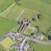
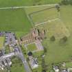
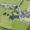
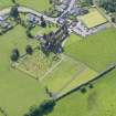
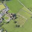
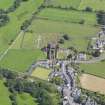
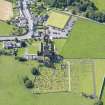
New Abbey, Sweetheart Abbey, Burial Ground


Burial Ground (Medieval), Cemetery (19th Century)
Site Name New Abbey, Sweetheart Abbey, Burial Ground
Classification Burial Ground (Medieval), Cemetery (19th Century)
Alternative Name(s) Cemetery
Canmore ID 213911
Site Number NX96NE 9.06
NGR NX 96559 66272
Datum OSGB36 - NGR
Permalink http://canmore.org.uk/site/213911


- Council Dumfries And Galloway
- Parish New Abbey
- Former Region Dumfries And Galloway
- Former District Nithsdale
- Former County Kirkcudbrightshire
Note (9 September 2011)
This site record was created to indicate a building which is, or was, listed but for which Canmore holds no supplementary information. Further information on listed buildings is available from http://portal.historicenvironment.scot/
Information from RCAHMS (SC) 9 September 2011

