
Den Of Boddam


Flint Deposit (Period Unknown), Flint Mine(S) (Neolithic) - (Bronze Age), Lithic Working Site(S) (Prehistoric)
Site Name Den Of Boddam
Classification Flint Deposit (Period Unknown), Flint Mine(S) (Neolithic) - (Bronze Age), Lithic Working Site(S) (Prehistoric)
Alternative Name(s) Sandfordhill; Boddom; Boddam Den
Canmore ID 21303
Site Number NK14SW 3
NGR NK 11470 41350
Datum OSGB36 - NGR
Permalink http://canmore.org.uk/site/21303


- Council Aberdeenshire
- Parish Peterhead
- Former Region Grampian
- Former District Banff And Buchan
- Former County Aberdeenshire
NK14SW 3.00 114 414
See also NK14SW 6.
(NK 1135 4150) Site of Supposed (NAT) Circles (NR)
OS 6" map, Aberdeenshire, 1st ed., (1868)
For excavated flint mines, see NK14SW 3.01.
See also NJ94SE 27 and NK04SE 41.
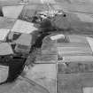
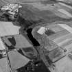
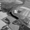
The remains of a chalk flint deposit, the major source of flint in Scotland, occurs, mainly above the 300' (91m) contour, on the ridge of high ground which runs westward for about 10 miles (13.4km), from the coast between Invernettle (NK 12 44) and Stirling Hill (NK 12 41) to west of Skelmuir Hill (NJ 98 41) and Hill of Dudwick (NJ 97 37). The flint, yellow in colour, occurs in the form of gravel, pebbles, nodules and boulders.
W Ferguson 1875; F H Groome 1901.
Flint-working pits, comparable with those on Skelmuir Hill (NJ94SE 27), are plainly visible lying in an irregular line near the top of both edges of a ravine about three-quarters of a mile long. Though the ground has not been cultivated, the edges of the pits are much broken, but some are still 2' to 3' deep. In one place numerous flakes, fragments and some anvils were found just below the peat. The pits are circular, 6' to 8' in diameter, although Childe mentions circular depressions 45' to 55' in diameter.
A Murray 1863; T F Jamieson 1868; Name Book 1868; G S Graham-Smith 1918; V G Childe 1946.
Numerous rough hollows about 6 to 8ft across and 2 to 3ft deep are visible on both sides of a ravine in the areas centred NK 1135 4141 and NK 1150 4137. Many pieces of flint were noted at the time of investigation.
Visited by OS (RL) 22 May 1972.
Easternmost exposure of flinty gravel deposit of Buchan plateau. Over 300 'flint pits' (the largest measuring about 7m across by 2m deep) are visible along the steep sides of the valley, and apparently result from flint working.
C R Wickham-Jones 1987.
Aerial photographs of flint pits during excavation (AAS/93/10/G22/5-8) held by Grampian Regional Council.
Information from Mrs M Greig, Grampian Regional Council, March 1994.
Air photographic imagery listed.
NMRS, MS/712/36.
Measured Survey (10 May 1993 - 14 May 1993)
A detailed survey of the flint mines in the Den of Boddam was conducted over a period of a week in May 1993. The full extent of the flint mines (450 pits, 8 ha) was mapped by EDM at a scale of 1:2500, while a sample of the pits on the slope below the area excavated by Alan Saville were drawn by self-reducing alidade at a scale of 1:500. Although the excavations have revealed complex sequences of pits cutting one another, the mines visible on the surface today appear to have migrated progressively further up the slope of the Den. Indeed, all the evidence gathered on the intensively exploited W side of the Den showed that the spoil dumps consistently overlay workings on their downslope sides.
Visited by RCAHMS (SH) 10-14 May 1993.
[DES 1993, 116-7]
Digital linework: Collection Item GV008746
Survey drawing of NW area: DC 40289 (pencil) and DC 40290 (ink)

