
Pricing Change
New pricing for orders of material from this site will come into place shortly. Charges for supply of digital images, digitisation on demand, prints and licensing will be altered.
Boddam Castle


Castle (Medieval)
Site Name Boddam Castle
Classification Castle (Medieval)
Canmore ID 21292
Site Number NK14SW 2
NGR NK 13209 41800
NGR Description Centred on NK 13209 41800
Datum OSGB36 - NGR
Permalink http://canmore.org.uk/site/21292


- Council Aberdeenshire
- Parish Peterhead
- Former Region Grampian
- Former District Banff And Buchan
- Former County Aberdeenshire
NK14SW 2 13209 41800
(NK 1320 4180) Boddam Castle (NR)
OS 6" map, (1959).
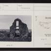
The remains of the 15-16th century Boddam Castle consist of the entrance archway, surmounted by a low gable, and one or two smaller arches as well as the complete foundation. What may have been the hinges of a drawbridge were found when a trench was cut in front of the entrance in 1868.
This was a seat of the Keiths of Ludquharn.
D MacGibbon and T Ross 1887-92; J B Pratt 1901; J Ferguson 1900.
Boddam Castle comprises the remains of a curtain wall, c.33.0m square, with the entrance in the W consisting of the W gable of a building with a round arched doorway and square window above. Three gun-loops are visible. The footings of a range of buildings remain within the enclosure against the N and S walls.
Resurveyed at 1:2500.
Visited by OS (RL) 22 May 1972.
Air photographs: AAS/97/12/G25/1 and AAS/97/12/CT.
NMRS, MS/712/29.
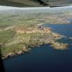
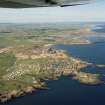
NK 1320 4180 A watching brief was carried out in January 2006 during the construction of a new pathway leading to Boddam Castle. The castle lies c 3km S of Peterhead on a level promontory between two deep vertical sided sea inlets. It was built by the Keiths of Ludquharn and dates to the late 16th to early 17th century. The path was c 1.6m wide and was excavated to a maximum depth of c 300mm. No archaeological features or finds were evident.
Report lodged with Aberdeenshire SMR and NMRS.
Sponsor: Boddam Community Council.
JC Murray, 2006.
Field Visit (October 2022)
NK 12312 47248 Visited during fieldwork by SCAPE. The surviving masonry is in a precarious structural condition. Remains of the curtain wall on the south side of the promontory is starting to collapse.
Information from S. Boyd and J. Hambly - Scottish Coastal Archaeology and the Problem of Erosion (SCAPE).

