
Wellhill


Enclosure (Period Unknown)(Possible), Pit(S) (Period Unknown), Ring Ditch(S) (Period Unknown)
Site Name Wellhill
Classification Enclosure (Period Unknown)(Possible), Pit(S) (Period Unknown), Ring Ditch(S) (Period Unknown)
Canmore ID 211838
Site Number NO66SE 54
NGR NO 6900 6020
NGR Description Centred NO 6900 6020
Datum OSGB36 - NGR
Permalink http://canmore.org.uk/site/211838


- Council Angus
- Parish Dun
- Former Region Tayside
- Former District Angus
- Former County Angus
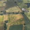
NO66SE 54 centred on 6900 6020
The following sites were recorded during summer aerial reconnaissance. Details of each site have been deposited in the NMRS.
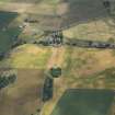
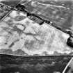
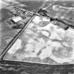
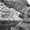
NO 690 602 Faint cropmarks of ring-ditches, ?circular enclosure and scattered pits.
Sponsors: Aberdeenshire Council, Angus Council, RCAHMS
M Greig 2001f.
(Location cited as NO 6907 6020 and name as Wellhill). Air photography (AAS/01/7/G10/7 and AAS/01/7/CT/40-3, all flown 17 August 2001) has recorded the faint cropmarks of ring-ditches, a possible circular enclosure, and scattered pits in a field of barley. The cited location falls on a gentle slope at an altitude of 15m.
NMRS, MS/1739.

