
Pricing Change
New pricing for orders of material from this site will come into place shortly. Charges for supply of digital images, digitisation on demand, prints and licensing will be altered.
Upcoming Maintenance
Please be advised that this website will undergo scheduled maintenance on the following dates:
Thursday, 9 January: 11:00 AM - 3:00 PM
Thursday, 23 January: 11:00 AM - 3:00 PM
Thursday, 30 January: 11:00 AM - 3:00 PM
During these times, some functionality such as image purchasing may be temporarily unavailable. We apologise for any inconvenience this may cause.
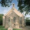
St Fergus, St Fergus Parish Church And Churchyard


Burial Ground (Post Medieval), Church (17th Century), Churchyard (Post Medieval), War Memorial (20th Century)
Site Name St Fergus, St Fergus Parish Church And Churchyard
Classification Burial Ground (Post Medieval), Church (17th Century), Churchyard (Post Medieval), War Memorial (20th Century)
Canmore ID 21109
Site Number NK05SE 5
NGR NK 09325 51967
Datum OSGB36 - NGR
Permalink http://canmore.org.uk/site/21109


- Council Aberdeenshire
- Parish St Fergus
- Former Region Grampian
- Former District Banff And Buchan
- Former County Aberdeenshire
NK05SE 5 09325 51967
NK05SE 18 09374 52011 The Glebe (Old Manse)
NK15SW 1 11573 50752 St Fergus's Church and Churchyard (Old St Fergus's Church)
(NK 0931 5196) Church (NR)
OS 6" map, (1959)
1763, fragmentary; 19th-century mort-house; 1644 belfry on 1869 kirk.
G Hay 1957.
In 1616 the Kirk was opened for service about 2 miles to the W of the old structure (NK15SW 1) and at a higher elevation (Henderson 1907).
It was rebuilt in 1763 with a belfry at one end, the latter now incorporated in the present church built 1869-70 (Eeles and Clouston 1960).
J A Henderson 1907; F C Eeles and R W M Clouston 1960.
No trace of the earlier church. Three old stones set in the E gable of the modern church, which is still in use, bear the dates 1616, 1763 and 1869. The bell cote on the W gable bears the date 1644.
Visited by OS (AA) 16 January 1969.

