
Following the launch of trove.scot in February 2025 we are now planning the retiral of some of our webservices. Canmore will be switched off on 24th June 2025. Information about the closure can be found on the HES website: Retiral of HES web services | Historic Environment Scotland
Berrybrae


Recumbent Stone Circle (Neolithic) - (Bronze Age), Beaker (Period Unassigned)
Site Name Berrybrae
Classification Recumbent Stone Circle (Neolithic) - (Bronze Age), Beaker (Period Unassigned)
Canmore ID 21099
Site Number NK05NW 2
NGR NK 02758 57161
Datum OSGB36 - NGR
Permalink http://canmore.org.uk/site/21099


- Council Aberdeenshire
- Parish Lonmay
- Former Region Grampian
- Former District Banff And Buchan
- Former County Aberdeenshire
NK05NW 2 02758 57161.
(NK 0275 5716) Stone Circle (NR)
OS 6" map, (1959)
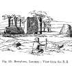
A recumbent stone circle, of which only 5 stones remain, inlcuding the recumbent stone, 10ft 10ins long, two massive blocks in situ (one the W pillar) and two prostrate and broken stones, one the E pillar. They are set into a complete circular bank, 45ft in diameter, the area enclosed being lower than the natural ground surface (Coles 1904). Calcined bones have been found within (TBFC 1887).
F R Coles 1904; Trans Buchan Fld Club 1887.
A recumbent stone circle, generally as described, except that the 'circular' bank is oval, and measures c.12.5m NW-SE by c.10.5m transversely.
Resurveyed at 1/2500.
Visited by OS (RL) 10 January 1969.
(Location cited as NK 0275 5716: nominated as Site of Regional Significance). This incomplete recumbent stone circle is situated on a shelf at an altitude of 40m OD. Only five stones remain, including the recumbent, two massive stone blocks in situ (one of them the W pillar) and two prostrate and broken stones (one of them the E pillar). They are set in an oval bank, the area enclosed being lower than the natural ground surface.
Excavation (in 1976) by A Burl revealed two phases. The first comprised a low oval bank of stones (12.8 by 10.8m) with a recumbent and nine standing stones around the perimeter of the bank. There was a ring-cairn in the central area with three cremation burials, and quartz fragments were found near the recumbent. In the second phase, the circle was wrecked, the standing being truncated apart from the recumbent and W flanker. The ring-cairn was levelled and a stone wall piled over the former bank and stone stumps to form an enclosed cremation cemetery. Charcoal associated with Beaker no. 4 of this phase has yielded radiocarbon determinations of 1500 +/- 80 BC (HAR-1849) and 1360 +/- 90 bc (HAR-1893).
The bank was reconstructed after excavation in 1976.
[GRC ground photographic imagery listed].
NMRS, MS/712/35 (visited 14 February 1997).
Field Visit (20 August 2003)
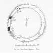
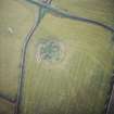
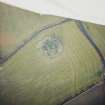
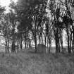
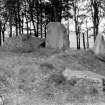
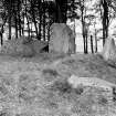
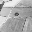
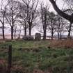
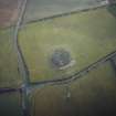
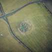
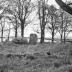
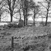
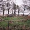
This recumbent stone circle is situated amongst deciduous trees within a large grass-grown roundel near the NE corner of an arable field to the NNE of Berrybrae. The circle now comprises the recumbent setting (1–3) and two orthostsats (9 & 10) set on the line of an oval ring-bank, but excavations by Burl in 1975–8 uncovered the stump of another orthostat on the SSE (4) and the shallow sockets of four others around the NE half of the ring (5–8). The recumbent (2), which stands on the SW, measures some 3.3m in length by 1.4m in height and the highest part of its rough and uneven top forms a central boss. The W flanker (1) is a large block standing 2.35m in height, but the E flanker (3) is reduced to a stump, with a detached fragment lying at its foot. Both are aligned with the leading edge of the recumbent, set at a slight angle to pick up the arc of the circle. As seen today, the heights of the stones on the W hint that the circle was graded to reduce in height from the tall W flanker (1); the orthostat on the NW (9), however, was re-erected in 1976 and its present height may be a misleading. The ring-bank, which forms a stony band from 1.6m to 3.5m in thickness by 0.25m in height, displays runs of inner kerbstones on the WNW and SSE respectively; the gently dished interior measures 11.6m from ESE to WNW by 9.2m transversely.
Visited by RCAHMS (JRS and KHJM) 20 August 2003
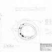
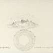
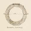
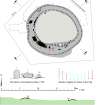
Measured Survey (20 August 2003)
RCAHMS surveyed Berrybrae recumbent stone circle on 20 August 2003 with plane table and alidade producing a plan and sections of the stone circle and an elevation of the principal stones at a scale of 1:100. The survey drawing was redrawn in ink and used as the basis for an illustration produced in vector graphics software for publication at a scale of 1:250 (Welfare 2011, 309).

