Cortes
Stone Circle (Neolithic) - (Bronze Age)(Possible)
Site Name Cortes
Classification Stone Circle (Neolithic) - (Bronze Age)(Possible)
Alternative Name(s) Cortie Brae
Canmore ID 21098
Site Number NK05NW 1
NGR NK 01007 59235
Datum OSGB36 - NGR
Permalink http://canmore.org.uk/site/21098
- Council Aberdeenshire
- Parish Rathen
- Former Region Grampian
- Former District Banff And Buchan
- Former County Aberdeenshire
NJ95NE 5 c. 99 59
Burl suggests that the 'Druid temple' on Cortes estate (Cortes House: NJ 999 594) referred to in NSA may have been a recumbent stone circle.
New Statistical Account (NSA) 1845; H Burl 1970; A Burl 1976.
NK05NW 1 0101 5924.
(NK 0101 5924) Standing Stone (NR) Stone Circle (NR) (Remains of)
OS 6" map, Aberdeenshire, 2nd edition (1902); OS 6" map, (1959)
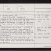
All that remains of this stone circle are three large stones, two of which appear to be in situ, the third having been palced in the centre. A portion of the circle was cultivated "some years ago" but nothing of importance was discovered. Name Book 1867.
Only two stones remain, one of which is standing 2ft 10in high, the other being prostrate. They rest on a roughly semi-circular mound 3ft high, which is confined by a wall. This is possibly an ancient mound upon which the stones were originally set, but more likely the stones were removed to this spot.
F R Coles 1904.
Prominently situated on a hill, this site is as described by Coles. Apart from the one large boulder set on top of the turf-covered mound, there is no evidence for an antiquity at this spot.
Visited by OS (RL) 10 January 1969.
Publication Account (2011)
A possible recumbent stone circle is listed under this name by Burl and Ruggles (Burl 1970, 79; 1976a, 351, Abn 34; 2000, 420, Abn 33; Ruggles 1984, 58; 1999, 185, no. 4). It is attributed to a reference to a ‘Druid temple on the estate of Cortes’ in the New Statistical Account (xii, Aberdeenshire, 293). This, however, probably refers to the one on Cortie Brae (cf Barnatt 1989, 460 no. 6:120, 484 no. 6:k), which does not appear in Burl’s gazetteer. The New Statistical Account does not mention any other stone circles in the parish and in 1870 the Cortie Brae circle was the only one known to the OS surveyors and their informants (Aberdeenshire 1872, viii), by which time it comprised only three stones (Name Book, Aberdeenshire, No. 76, p 96). To add to the confusion, Rev John Pratt’s account of Buchan places the Druidical circle referred to in the New Statistical Account two miles south-west of Rathen Church (1858, 149) rather than on Cortie Brae to the south-east; this was compounded by Robert Anderson in revising the text for the 4th edition at the end of the century, for he adds that a single stone still marked the spot (Pratt 1901, 247). Like many such sources, the directions and distances should not be taken too literally – for example Trefor Hill is placed north-east of the church rather than north – and it is perhaps more telling that Cortie Brae otherwise escapes Pratt’s and Anderson’s notice. Indeed, Anderson is almost certainly referring to Cortie Brae, where in 1903 Coles found a single stone set upright (1904, 290–1). However, neither these remains nor the earlier accounts give any grounds to suggest that there was a circle with a recumbent setting on the Cortes estate.
Information from RCAHMS (ATW), 2011
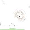
Measured Survey (13 February 2018)
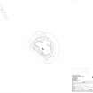
HES surveyed Cortes stone circle with plane-table and alidade on 13 February 2018 at a scale of 1:100. GNSS data was also collected to record a section across the site. The resultant plan and section were redrawn in vector graphics software.


