
Pricing Change
New pricing for orders of material from this site will come into place shortly. Charges for supply of digital images, digitisation on demand, prints and licensing will be altered.
Rattray, Castle Hill


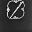
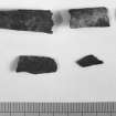
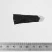
Castle (Medieval), Kiln(S) (Period Unassigned), Well (Period Unassigned), Coin(S) (Silver), Unidentified Flint(S) (Flint), Unidentified Pottery (Medieval)
Site Name Rattray, Castle Hill
Classification Castle (Medieval), Kiln(S) (Period Unassigned), Well (Period Unassigned), Coin(S) (Silver), Unidentified Flint(S) (Flint), Unidentified Pottery (Medieval)
Alternative Name(s) Old Rattray
Canmore ID 21092
Site Number NK05NE 4
NGR NK 0880 5797
Datum OSGB36 - NGR
Permalink http://canmore.org.uk/site/21092


First 100 images shown. See the Collections panel (below) for a link to all digital images.
- Council Aberdeenshire
- Parish Crimond
- Former Region Grampian
- Former District Banff And Buchan
- Former County Aberdeenshire
NK05NE 4 0880 5797.
(NK 0880 5797) Castle (NR) (Site of)
(NK 0887 5793) Well (NR)
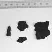
(NK 0875 5789) Coins found (NAT).
OS 6" map, (1959).
See also Rattray burgh, NK05NE 4.
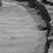
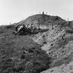
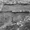
The Comyn family held a castle here in the early 13th century, but after their defeat by Robert the Bruce, the Earldom of Buchan was despoiled. (Pratt 1901) Simpson (1951) notes it as one of the nine castles of the Knuckle (the NE promontory of Buchan). In 1870 Castle Hill was a cultivated oval eminence, apparently artificial, which, according to local information, had originally been surrounded by a moat, before being filled with windblown sand. Castle Hill Well stood a little to the S. A quantity of regularly-laid stones, assumed to be the foundations of the castle, were removed c.1734, and some silver coins (date unknown) have also been found (ONB 1870). A "well-made causeway" was discovered at the foot of the mound whilst making drains. (TBFC 1887). Cumine (1887) believes that the name Rattray is derived from "rath" a prehistoric fort, and suggests that the hillock is the site of an earlier defensive work. J Cumine; Ordnance Survey Name Book (ONB) 1870; TBFC 1887; J D Pratt 1901; W D Simpson 1951.
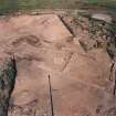
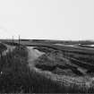
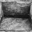
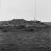
Castle Hill, an oval natural hillock, with its top slightly dished, measures c.40.0m N-S by 55.0m transversely. Apart from a slight depression around the W arc, which may be the remains of a ditch, the hill bears no trace of artificial features. The castle well has been modernised and forms the water supply for Old Rattray farm. No further information regarding finds.
(A covered concrete tank occupies the site of the well).
Visited by OS (RL) 13 January 1969.
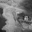
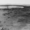
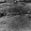
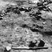
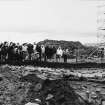
Nearly two thirds of castle mound excavated revealing foundations of main 13th century phase with perimeter wall including two mural buildings and harbour-side entrance, and a multistoried building freestanding on mound centre. Coin and ceramic dating 13th to early 14th century. After destruction c 1308, some secondary occupation including possible industrial kilns.
H K Murray and J C Murray 1986.
Motte.
P A Yeoman 1988.
'Extension of excavation on the castle mound revealed large secondary building, possibly dating from mid-14th century. The mound section related the mound build up and perimeter bank and wall remains to a deep defensive ditch at the mound base.'
A fourth season of excavation concentrated on two main areas:-
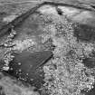
The Castle Mound. Excavation of the 14th century stone structures is now complete revealing a main rectangular building c 20m by 6.5m internally and two smaller subsidiary buildings. The main building was of some sophistication and more domestic than military in character. In one area there is some indication of earlier structures on the mound top, sealed by the mound levelling, on which the 14th century buildings were built.
The Castle Field. A series of large areas was excavated in the field near the base of the castle mound in order to discover if there was an early burgh nucleation near the castle. The results showed some evidence of medieval occupation but not enough to suggest any intensive burgh development in this area. This medieval occupation was built on a sand bank which sealed well defined plough marks related to a burnt wattle fence. Pottery and flints suggest a Neolithic date but this has yet to be confirmed by C14 dating.
H K Murray and J C Murray 1988.
A fifth season of excavation completed work on the castle site.
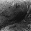
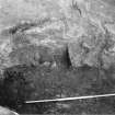
Castle mound. Excavation over the past few years revealed that the 14th- century stone foundations had been built on a deposit of c5m of sand. In 1989, this was removed over an area c12 by 20m. Below it, cut into the natural dune top was an annular gully, enclosing an area 4-5m in diameter. Several post-pits and post-holes were associated. These features can be positively dated to the 13th century and must represent the earliest, short-lived and possibly defensive use of the mound. Sponsor: SDD HBM.
H K and J C Murray 1989.
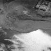
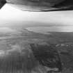
Visible on air photograph AAS/93/15/G30/31. Copy held by Grampian Regional Council.
Information from M Greig, Grampian Regional Council, March 1994.
'Castle Hill' occupies a stable sandhill at an elevation of about 15m OD.
[Air and ground photographic imagery listed].
NMRS, MS/712/36, visited 4 July 1977.
Excavation (1985 - 1990)
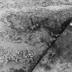
Large scale trial trenching in burgh area between castle (NK05NE 4) and church revealed possible medieval to late medieval occupation floor. Pottery kiln found with pottery at all stages of production; 13th century date indicated by partly fired imitation of Grimston type vessel in local fabric. Magnometer survey being undertaken to identify further kiln sites (cf NK05NE 5).
H K Murray and J C Murray 1986.
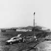
Open plan excavation of an area 20m by 40m took place in the burgh zone, near 1986 pottery kiln and over the area of 1986 magnotometer survey. This revealed 14th-15th century industrial complex covering two adjacent properties, one with extensive metal working, predominantly iron, the other with the pottery kiln and a series of smaller kilns, work floors and drainage systems.
H K Murray and J C Murray 1987.
Excavations in 1989, in an area opposite the 13th-century burgh church revealed 14-15th century occupation. This area appears to have been a later extension of the built-up part of the burgh, and it is unlikely that the church was the initial focus of the settlement.
A series of three large areas was excavated in the field opposite the modern farm, where evidence of clay-walled domestic buildings was
found.
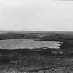
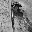
Trial trenching alongside the loch indicated the extent of salt marshes, possibly used for seasonal grazing.
H K and J C Murray 1989
The sixth and final season of excavation of this deserted medieval burgh took place in July 1990.
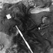
Work concentrated on the domestic area of the burgh. Property boundaries were found linking to those in the industrial area excavated in 1986/7. On one of the properties there had been a fairly substantial clay-walled building. This had burnt down, leaving burnt timbers and organic debris which appeared to be heather, but which is yet to be identified. The debris lay over the floor level, suggesting fallen roofing materials. The finds confirmed this building was likely to have been a dwelling.
On the N of the site a small hearth, possibly used for melting lead, a slight scatter of slag, and the physical links of some pottery, suggest contemporaneity with the industrial area excavated previously. The dwelling may have belonged to one of the craft workers.
Post-excavation work is well in progress and examination of the local pottery shows a range of over 30 products, some fairly sophisticated. This will be one of the most comprehensive assemblages of local medieval pottery in the NE.
Sponsor: HBM
H K and J C Murray 1990

