
Pricing Change
New pricing for orders of material from this site will come into place shortly. Charges for supply of digital images, digitisation on demand, prints and licensing will be altered.
Upcoming Maintenance
Please be advised that this website will undergo scheduled maintenance on the following dates:
Thursday, 30 January: 11:00 AM - 3:00 PM
During these times, some functionality such as image purchasing may be temporarily unavailable. We apologise for any inconvenience this may cause.
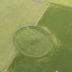
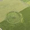
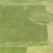
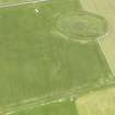
Maes Howe


Mound(S) (Period Unassigned)
Site Name Maes Howe
Classification Mound(S) (Period Unassigned)
Alternative Name(s) Maeshowe
Canmore ID 2107
Site Number HY31SW 21
NGR HY 31759 12826
Datum OSGB36 - NGR
Permalink http://canmore.org.uk/site/2107


- Council Orkney Islands
- Parish Stenness
- Former Region Orkney Islands Area
- Former District Orkney
- Former County Orkney
HY31SW 21 31759 12826
HY 3175 1282. A number of low, possibly artificial, mounds are situated 'in the immediate vicinity' of Maes Howe (HY31SW 1): their general appearance is suggestive of burial mounds.
NW of Maes Howe and just outside the enclosing rampart is a large heather-grown mound measuring 70ft by 62ft by about 4ft high. "There are indications of one laid stone, and the top shows a hollow as if it had been dug into".
On the NE of Maes Howe a farm road crosses the moor. "On the farther side of the road and for the most part in uncultivated ground, is a group of six earthen mounds. The three nearest to Maes Howe lie close together at a distance of from 250 to 300 yards. No 1, the most southerly, is low and hollowed on the top, and is 21ft diameter. The other two, nos 2 and 3, stand about 50 yds N of No 1, and touch one another. They measure respectively 23ft diameter by 3ft high, and 18ft diameter by 2ft high. No 4 is situated about 150 yds further N, beside a lane bounded by wire fences, in the setting up of which it has been partially destroyed. It is 35ft in diameter by 2ft 6ins in height.
No 5 lies on the S side of the lane between this and the main road. It measures 31ft in diameter and is 3ft high. Two smaller mounds impinge on it.
No 6 lies in a field between the croft of Upper Bigging and the lane, about 40 yds NW of no 4. It measures 36ft in diameter and is 2ft 6ins in height. It is grass-grown and has been disturbed by digging."
On the SE of Maes Howe and outside the enclosing rampart in a ploughed field, two slightly raised areas, from 12 to 15ft in diameter, stand out (August 1928) as soil-marks. Large quantities of stones have been removed from them during the previous two years, and they may have been small burial cairns.
RCAHMS 1946.
The fields to the N and NE of Maeshowe have either been cultivated or contain a now-disused military camp, so that only the remains of one mound "just outside the enclosing rampart of Maes Howe" can be positively identified as that described by the Commission. It is situated at HY 3175 1282 (A) and measures 18.0m in diameter by 1.2m maximum height with a central depression c.5.0m in diameter. It is composed mainly of earth, with a few stones protruding through the turf.
The other mounds reported by the Commission could not be identified, but at HY 3188 1308 (B) and HY 3183 1303 (C) are the possible remains of two others, just traceable as light-coloured patches containing a few stones and as distinct rises, 0.9m high, on the line of two fences. The mounds were removed in 1962 by Mr Findlay, who was formerly employed on restoration work at Maeshowe by the MOW. Nothing was found (Information from Mr J W Findlay (farmer), Over Bigging, Stenness, Orkney). The mound at HY 3188 1308 appears to have been oval, measuring 12.0m by 10.0m, while that at HY 3183 1303 was circular, measuring 12.0m in diameter. These two mounds cannot be related to any mentioned in the Commission report.
To the SW of these, and along the same fence line, are two other rises, not so pronounced, at HY 3178 1299 and HY 3177 1298. These are contiguous and may be the Commission's nos 2 and 3. The most southerly, no 1, could not be located.
The lane, farm road and croft (the name of the croft not being supplied in the original recording), could not be identified, making the identification of nos 4, 5 and 6 impossible, although the surmise that mounds 2 and 3 are identifiable would locate mound no 4 at either HY 3183 B or C.
No trace could be found of the "circular areas" to the SE of Maeshowe, and no further information was discovered.
Extant mound (A) surveyed at 1/2500: possible sites of mounds positioned at 1/10,560.
Visited by OS (RB) 25 May 1966.
All that remains of Upper Bigging is a single structure at HY 3181 1326, the other farm buildings are no longer depicted on the OS Explorer series 1:25,000 scale maps. This means that the track referred to in the text above is the one running presently from a point just east of Overbigging and the road is the Stoneyhill Road. Working back from Upper Bigging as a reference all six of the sites mentioned in the Inventory (RCAHMS 1946), as NE of Maes Howe must have been east of the Stoneyhill Road. This means that the very tentative identification of numbers two and three with items B and C noted by the Ordnance Survey in 1966 is incorrect.
Information via e-mail to RCAHMS from Mr Martin Howe, 23 November 2007
Field Visit (9 September 1993)
Visited during the course of the Orkney Barrows Project, it was noted that only one mound remained of a dispersed group of six or seven mounds. (HY 31750 12820). The cemetery was probably akin to the mounds around Brodgar.
Since the OS survey this mound has reduced in height from 1.2m to 0.45m and has been spread to a larger diameter (18.0m). Some stones are visible. The mound is prominent to the S and NE, and is obscured to the W and E.
Information from the Orkney Barrows Project (JD), 1993

