
New Mains


Chimney Stalk (Late 19th Century), Engine House (Late 19th Century), Farmstead (Late 19th Century)
Site Name New Mains
Classification Chimney Stalk (Late 19th Century), Engine House (Late 19th Century), Farmstead (Late 19th Century)
Canmore ID 210606
Site Number NT58SW 149
NGR NT 50726 81410
NGR Description Centred NT 50726 81410
Datum OSGB36 - NGR
Permalink http://canmore.org.uk/site/210606


- Council East Lothian
- Parish Dirleton
- Former Region Lothian
- Former District East Lothian
- Former County East Lothian
NT58SW 149 NT 5072 8141
Archaeological works between September and November 2005 comprised historic building recording and associated
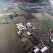
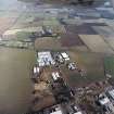
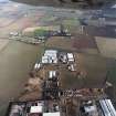
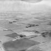
research regarding a part Grade B listed double courtyard steading (NT58SW 149) in advance of reconstruction as accommodation.
The desk-based assessment and building recording suggested that the steading was founded as a double courtyard with a steam engine, stack and barn in the mid-19th century. Later additions increased the covered area without expansion of the original quadrangle in the 19th century. Much of the steading survived relatively well into the later 20th century, and it is only in the last ten years that whole ranges and roofs have been demolished and removed without recording. The steading included a number of designed elements of status and, although dilapidated, had been a farm of some size and quality, incorporating quality dressed stone and basic Palladian principles.
Report and archive to be deposited in East Lothian SMR.
Sponsor: Avento Architecture and Design.
G Geddes 2005
Standing Building Recording (September 2005)
In September 2005, Headland Archaeology ltd undertook a Level 2 Historic building survey at Fenton Newmains Steading, prior to redevelopment of the buildings into housing. The steading was founded as a double courtyard with a steam engine, stack and barn in the mid 19th century (1844-1853 based on cartographic and building archaeology, rather than late 19th as in HS listing). Additions were built on in the 19th century. Since 1990, the steading has been partly demolished without recording.

