
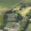
Seton Mill


Mill (18th Century)
Site Name Seton Mill
Classification Mill (18th Century)
Canmore ID 210439
Site Number NT47NW 90
NGR NT 41671 75313
NGR Description Centred on NT 41671 75313
Datum OSGB36 - NGR
Permalink http://canmore.org.uk/site/210439


- Council East Lothian
- Parish Tranent
- Former Region Lothian
- Former District East Lothian
- Former County East Lothian
NT47NW 90.00 centred 41671 75313
NT47NW 90.01 NT 41689 75177
The Object Name Book of the Ordnance Survey (ONB) decribes the mill as ' A corn mill, having a dwelling house and offices also a few acres of land attached, the property of the Earl of Wemyss' ONB 1853.
The mill is depicted on the 1st edition of the OS 6-inch map (Haddingtonshire, 1854, sheet 9) and the current ediiton of the )S 1:2500 scale digital map shows the buildings as 'Mill Cottages'.
Information from RCAHMS (DE), Janaury 2008

