
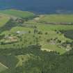
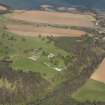
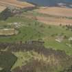
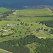
Dunglass House, Walled Garden


Walled Garden (18th Century)
Site Name Dunglass House, Walled Garden
Classification Walled Garden (18th Century)
Canmore ID 209377
Site Number NT77SE 7.08
NGR NT 76235 72071
NGR Description Centred NT 76235 72071
Datum OSGB36 - NGR
Permalink http://canmore.org.uk/site/209377


- Council East Lothian
- Parish Oldhamstocks (East Lothian)
- Former Region Lothian
- Former District East Lothian
- Former County East Lothian

