
Scheduled Maintenance
Please be advised that this website will undergo scheduled maintenance on the following dates: •
Tuesday 3rd December 11:00-15:00
During these times, some services may be temporarily unavailable. We apologise for any inconvenience this may cause.
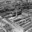
Monkland Canal, Glasgow, Cut Of Junction, St. Rollox Basin


Canal Basin (18th Century) - (19th Century)
Site Name Monkland Canal, Glasgow, Cut Of Junction, St. Rollox Basin
Classification Canal Basin (18th Century) - (19th Century)
Canmore ID 209041
Site Number NS66NW 381.01
NGR NS 6012 6619
NGR Description From NS 6024 6620 to NS 6000 6619
Datum OSGB36 - NGR
Permalink http://canmore.org.uk/site/209041


- Council Glasgow, City Of
- Parish Glasgow (City Of Glasgow)
- Former Region Strathclyde
- Former District City Of Glasgow
- Former County Lanarkshire
NS66NW 381.01 From 6024 6620 to 6000 6619.
This section of the Cut of Junction (NS66NW 381.00) was situated outside the Tennant's Chemical Works (NS66NW 268) at St. Rollox. The basin was infilled in the 1960s.
G Hutton 1993.
This basin is clearly marked on the 1st edition of the OS 6-inch map (Lanarkshire 1865, sheet vi) and on the 2nd edition of the OS 6-inch map (Lanarkshire 1896, sheet viNE).
Information from RCAHMS (MD) 14 February 2002.

