
Finstown, The Hillock


Broch (Iron Age)(Possible)
Site Name Finstown, The Hillock
Classification Broch (Iron Age)(Possible)
Alternative Name(s) Hillock Broch
Canmore ID 2088
Site Number HY31SE 4
NGR HY 3611 1415
Datum OSGB36 - NGR
Permalink http://canmore.org.uk/site/2088


- Council Orkney Islands
- Parish Firth
- Former Region Orkney Islands Area
- Former District Orkney
- Former County Orkney
HY31SE 4 3611 1415
See also HY31SE 28.
(HY 3611 1415) Brough (NR) (Site of)
OS 6" map, Orkney, 2nd ed., (1903).
'Broch (probable), The Hillock'. This extensive mound, about 80 yds by 40 yds, is "certainly a prehistoric structure of some kind but its precise nature cannot be determined without excavation: such traces of building as are there are too indefinite to be interpreted with confidence".
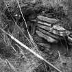
Road construction has revealed in the west side of the mound a sector of a double wall, 32 ft wide overall, the inner wall 16 ft thick and the outer composed of smaller stones, "evidently a secondary erection". (J Fraser 1927)
Two fragments of pottery and a boar's tusk found on the site by the Commission in 1928 are in the Orkney Arch. Soc. Museum, Kirkwall. Listed by Petrie as a broch (G Petrie 1873) but by Graham (A Graham 1949) as an uncertain example, it is scheduled as a broch.
RCAHMS 1946.
The Hillock is a turf-covered amorphous mound of earth and stones, about 80.0m. by 25.0m. by 4.2m. maximum height, generally as described by the Commission, on a low peninsula just above sea-level.
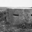
Minor excavation in the top of the mound, adjacent to a modern gun-position (Pillbox, HY31SE 28), has revealed drystone walling forming a cell-like structure 1.5 m. in diameter, and a square structure 2.0m. across and 1.2m. high, joined by a narrow passage, with a further passage leading from the south side of the square cell. Insufficient detail is exposed to identify these features but they obviously post-date the mound. Traces of drystone walling are visible in the cliffs at the east side of the mound, but no wall-faces could be identified. The situation is typical for a broch.
Surveyed at 1/2500.
Visited by OS (NKB) 29 April 1966.
HY 361 141 Numerous anomalies of archaeological potential were noted in a gradiometer survey in October 2004. It is likely that the majority of these are due to settlement remains associated with Hillock Broch (HY31SE 4) which lies immediately to the E, across the road. Two ditch-type anomalies of possible archaeological significance were also located, although it seems unlikely that these are contemporary with the broch.
Sponsor: Mott MacDonald for Scottish Water Solutions.
S Ovenden 2004
HY 360 140 (centre) A desk-based assessment and walkover survey were completed between January and March 2005 ahead of a proposed waste water transfer system. The entire line of the two alternative proposed routes of pipeline track and the areas of the pumping station and outflows were surveyed. No new features of archaeological interest were identified.
The site of the proposed pumping station and associated pipeline opposite Hillock Broch (HY31SE 4), on the W side of the A966, were evaluated by trial trenching. This confirmed the presence of archaeological features associated with the broch settlement. The presence of an extensive rock-cut ditch, suggested by an earlier geophysical survey, was confirmed.
Report lodged with Orkney SMR and NMRS.
Sponsor: Mott MacDonald for Scottish Water Solutions.
J Robertson 2005
HY 361 142 (centred on) An archaeological evaluation was undertaken ahead of a proposed wastewater transfer system development in Finstown, Orkney. The evaluation was in the field opposite the Scheduled Ancient Monument, Hillock Broch, to the west of the A966. The assessment comprised two areas: the proposed pumping station (site 1) and the proposed route of the associated pipeline (site 2). In site 1, three strip test trenches were excavated providing a 10% sample of the development site covering an area of c. 115m square. In site 2 a strip test trench, c.114m long, was excavated along the proposed route of the pipeline. The trenches in both the sites revealed archaeological features probably associated with the broch.
J Mullan 7 March 2005.
HY 361 141 (centred on) An archaeological watching-brief was undertaken during the ground breaking works of a temporary wastewater transfer system at Finstown, Orkney. This work followed a geophysical survey (Ovenden 2004), a desk-based and walkover survey (Robertson 2005) and an intrusive archaeological evaluation (Mullen 2005). The watching-brief covered the stripping of a 25m by 25m compound area and the length of temporary pipeline from the new housing development on the east side of the A966 across the A966 westwards to the shore of the Ouse where a new temporary septic tank was being installed. Only two features or deposits of archaeological or historic interest were revealed. The features were an earlier metalled road surface underlying the present main road (A966) and a shallow scoop with charcoal lenses was revealed 26m into the field from the A966.
J Robertson 17 May 2005.
Publication Account (2002)
HY31 6 FINSTOWN ('The Hillock' or 'Oyce')
HY/361142
A possible broch in Firth, consisting of an extensive grass-grown mound containing structures of some kind. Part of a circular wall 4.9 m (16 ft.) was exposed many years ago [3] during road construction. Two fragments of pottery and a boar's tusk were picked up in 1928 [4].
Sources: 1. OS card HY 31 SE 4: 2. G. Petrie 1890, 92: 3. G. Petrie 1927, 52: 4. RCAHMS 1946, 2, no. 323, 92.
E W MacKie 2002
Watching Brief (28 October 2007 - 19 November 2007)
HY 3611 1415 The bases of four separate cut features were recorded during excavations for a new sewer pipeline on 28 October–19 November 2007. These were provisionally interpreted as multiple ditches associated with the nearby Hillock Broch.
Report: Orkney SMR and RCAHMS
Funder: Scottish Water Solutions
Dave Lawrence (ORCA), 2008

