
Sands Of Forvie


Hut Circle(S) (Prehistoric), Midden(S) (Period Unknown), Bead(S) (Jet)(Period Unassigned), Bracelet(S) (Jet)(Period Unassigned)
Site Name Sands Of Forvie
Classification Hut Circle(S) (Prehistoric), Midden(S) (Period Unknown), Bead(S) (Jet)(Period Unassigned), Bracelet(S) (Jet)(Period Unassigned)
Alternative Name(s) 'The Forvie Site'; East Cottage; Sands Of Forvie Nature Reserve
Canmore ID 20850
Site Number NK02NW 2
NGR NK 01037 26352
NGR Description NK 01037 26352 and NK 01073 26332
Datum OSGB36 - NGR
Permalink http://canmore.org.uk/site/20850


- Council Aberdeenshire
- Parish Slains
- Former Region Grampian
- Former District Gordon
- Former County Aberdeenshire
NK02NW 2 01037 26352 and 01073 26332
For nearby cairns, see NK02NW 13.
See also NK02NW 3.
(Centred NK 0105 2629) The 'Forvie Site'
Information from A C O'Dell October 1953
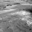
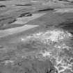
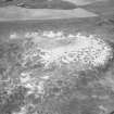
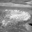
Within an area 300 yds by 100 yds (400 yds by 60 yds [W Kirk 1953]) along the crest of a sand-covered ridge, is a settlement of 19 circular huts, part of which is still buried under the dune ridge to the W.
The huts vary from 20-40 feet in diameter. Their floors are sunk into the sand underlying a heath surface, and covered with red clay or paving stones. The walls are formed by banking up the excavated sand, and stabilising it with clay and turf to carry a stone kerb. Inside, posts supported the roof timbers. The entrances are invariably on the E side. Jet beads and bracelets, and a mass of coarse undecorated pottery were found both within and outside the huts, indicating an Late Bronze Age/ Early Iron Age date. Outside the huts amid a scatter of fire-cracked stones are traces of working places, where saddle and flat rotary querns have been found. Occasional middens containing animal bones are evident (W Kirk 1958).
Seven of the huts (described by Kirk as stone circles) and an adjacent ring cairn (See NK02NW 16) were discovered in 1951. The cairn, one of the huts, and a "domestic site" were excavated (Kirk's sites "A, B,
& C" respectively. Another hut "D" is described but was not excavated. (see W Kirk 1953) Of the remaining five huts (which are not described) one ('E') lies 40 yards to the W of hut 'D', two more (F & G) occur about 150 yds N of D, the fourth ('H') is to the S of hut B and the fifth (J) lies close to domestic site C (W Kirk 1953).
Subsequent investigation revealed another 12 huts, at least one of which stood within an outer palisade.
W Kirk 1953; W Kirk 1955; W Kirk 1958.
Since Kirk's examination of this settlement, centred NK 010 263, drifting sand has encroached upon it and only four huts can positively be identified (B, D, E & F).
Hut 'B' is largely obscured by sand blow and is only identifiable as a hut from Kirk's excavation report.
'D' is as described by Kirk. The discontinuous 'inner circle' of stone is probably the remains of a retaining wall.
'E' measures 18.0m in diameter between the centres of a wall of similar construction to 'D'. Extending inwards from the south side of the entrance in the east is a bank of stones c. 3.0m long and c. 0.2m. wide.
All that is visible of 'F' is the east arc comprising a line of eight stones set on edge protruding through the sand.
About 20.0m. south of hut 'B' is a scattered arc of stones, 'H', appearing out of the E base of the dune ridge. Although Kirk notes this as a hut, there is insufficient visible to support his classification.
Huts 'G' and 'J' and the twelve huts found subsequent to Kirk's report of 1953 cannot be located and there is doubt as to their authenticity, as a map prepared by Aberdeen University from a Hunting air survey shows no huts. It is felt that students may have misidentified scattered stones as huts.
All that remains of Kirk's 'domestic site C' is an amorphous pile of stones, partly sand covered, exhibiting no built structure. It may be a working area associated with the huts.
Around the huts are numerous scatters of stones, some of which are fire-cracked, and to the NW of hut 'D' is a paved area. No middens were seen. There is no evidence of cultivation. In the collection of Mr W Middleton (information from Mr Middleton, 109 Gairn Terrace, Aberdeen) is a stone hand hammer found by him in 1953 in the area immediately to the north of hut 'D'.
Surveyed at 1/2500.
Visited by OS (RL) 27 August 1970.
Air photograph: AAS/97/13/CT.
NMRS, MS/712/29.
Scheduled with NK02NW 3 as 'Sands of Forvie, hut circles and ring cairn 1020m E of East Cottage... a complex of prehistoric remains...'
Information from Historic Scotland, scheduling document dated 30 March 2009.
Field Visit (28 March 2000)
The inclusion of Sands of Forvie in lists of recumbent stone circles has come about through a series of misunderstandings and misidentifications, probably initiated by the wording of Professor William Kirk’s report of some of his excavations. In the introduction to the various structures emerging from the sand he employed the term stone circles, but as a description rather than a classification, while in his conclusions he wrote that the small ring-cairn (NK02NW 3) he had discovered exhibited ‘in more complete fashion, on a smaller scale, the structural characteristics of many ring-cairns enclosed by recumbent stone circles’ (1954, 169). While there is no evidence that Alexander Thom had read Kirk’s report, it is presumably this that drew him to the Sands of Forvie, specifically to the stone circle Kirk referred to as Site D (1954, 158; Ralston and Sabine 2000, 11, ID). In his report Kirk mentioned that the stones of its wall increased in height towards the entrance on the east, where two jamb-stones 0.9m long lay fallen in the sand. Thom surveyed what he could see of this structure, including one of these jamb-stones, and it turned out to be elliptical on plan; the survey also covered the ring-cairn a short distance to the south, which he annotated concentric circles (RCAHMS DC4404). He interpreted the elliptical structure as a megalithic setting, publishing the plan in Megalithic Sites in Britain (Thom 1967, 79, fig 6.20), where an entry for Sands of Forvie in one of his tables is accompanied by the letters CR, C and CC, codes for Recumbent Stone Circle, Circle and Concentric Circles respectively (1967, 136, Table 12.1). The arrows and annotations on the plan direct the reader ‘to concentric circles’ on the south, and ‘to much disturbed circle’ to the north-west. Reconciling these annotations to the letter codes, it would appear that the elliptical structure, Kirk’s Site D, is Thom’s recumbent stone circle; it was probably excavated by Kirk in 1955, producing a domestic assemblage, and is almost certainly a hut-circle (Ralston and Sabine 2000, 11). The appearance of Sands of Forvie as a possible recumbent stone circle in Burl’s lists (1976a, 351, Abn 49) must come directly from Thom’s table, but it would appear that Burl, quite correctly, could not believe that the plan that Thom had published represented a recumbent stone circle. Therefore, he seems to have concluded that it was one of the other circles annotated on the plan; and as he knew that the concentric circles to the south were Kirk’s ring-cairn, he deduced that the ‘much disturbed circle’ to the north-west was the recumbent stone circle – his reasoning duly given away in his lists by the conversion of its diameter from megalithic yards to metres. In any case, he recognised that the ellipse was probably a hut-circle (Thom et al 1980, 192–3), though he did not make the connection between this other circle to the north-west and Kirk’s Site E, another probable hut-circle (Kirk 1955; Ralston and Sabine 2000, 11–12, IE). Thereafter debate and misunderstanding has continued, with Ruggles evidently not convinced that there was a recumbent stone circle here (1984, 57 note u), and Barnatt preferring to interpret Thom’s two circles as additional ring-cairns (1989, 485, no. 6:r). Ruggles finally concluded that there was no more than Kirk’s ring-cairn adjacent to an extensive settlement in the dune system (1999, 187 no. 79, 266 note 19), but still the existence of a possible recumbent stone circle in the Sands of Forvie has persisted, appearing in the most recent recension of Burl’s gazetteer, which also acknowledges Barnatt’s interpretation (Burl 2000, 420, Abn 49). It can only be repeated in conclusion that there is no recumbent stone circle amongst the structures recorded in the Sands of Forvie, and to date only one ring-cairn.
Visited by RCAHMS (ATW) 28 March 2000
Measured Survey (28 March 2000)
RCAHMS surveyed Sands of Forvie hut circles and ring cairn on 28 March 2000 with plane table and alidade producing a location plan at a scale of 1:250. The plan was used as the basis for an illustration, produced in ink and finished in vector graphics software, that was published at a scale of 1:1000 (Welfare 2011, 539).
Field Visit (October 2022)
NK 01037 26352 Visited during fieldwork by SCAPE. 12-14m diameter stone hut circle, visible due to prior excavation.
Information from S Boyd and J Hambly - Scottish Coastal Archaeology and the Problem of Erosion (SCAPE).

