
Following the launch of trove.scot in February 2025 we are now planning the retiral of some of our webservices. Canmore will be switched off on 24th June 2025. Information about the closure can be found on the HES website: Retiral of HES web services | Historic Environment Scotland
Forvie Church


Church (Medieval), Midden (Medieval), Village (Medieval), Pin (Bronze)(14th Century), Spindle Whorl(S) (Medieval), Unidentified Pottery (Medieval)
Site Name Forvie Church
Classification Church (Medieval), Midden (Medieval), Village (Medieval), Pin (Bronze)(14th Century), Spindle Whorl(S) (Medieval), Unidentified Pottery (Medieval)
Alternative Name(s) St Adomnan's Church; St Adamnan's Church; Forvie Kirk; Sands Of Forvie, Old Church; Forvie Village; Forvie National Nature Reserve; Waterside
Canmore ID 20839
Site Number NK02NW 1
NGR NK 02071 26620
Datum OSGB36 - NGR
Permalink http://canmore.org.uk/site/20839


- Council Aberdeenshire
- Parish Slains
- Former Region Grampian
- Former District Gordon
- Former County Aberdeenshire
Forvie Kirk, medieval. Given by James VI to King's College, Aberdeen, 1574; annexed to Slains. Very plain, ruined rectangle with door at west end of south wall. Dug out of covering sand by local doctor at end of 19th century when the piscina was unearthed.
Taken from "Aberdeenshire: Donside and Strathbogie - An Illustrated Architectural Guide", by Ian Shepherd, 2006. Published by the Rutland Press http://www.rias.org.uk

NK02NW 1 0204 2661
See also NK02NW 14.
NK 0207 2661) Forvie Church (NR) (Ruin).
OS 6" map 1959.
The church of Forvie, dedicated to St Adamnan, (H Scott et al 1926) is first mentioned in the 13th century records of the Chartulary of Arbroath and has early associations with a foundation of the Knights Templar (mentioned, but not supported by Easson). The parish appears to have maintained its independence until 1573 when it was united with Slains parish (W Kirk 1958).
The church was excavated in 1957-8 revealing a plain oblong structure, measuring 45' by 15' internally, with walls 2'0" thick pierced by entrances in the N and S. It probably dates from the late 12th century, and intrusive burials suggest that it became ruined in the 15th century. Finds include 13/14th century potsherds, coins and metalwork. (W Kirk 1957; 1958) In 1876, a piscina from within the church was donated to the National Museum of Antiquities of Scotland (NMAS) (PSAS 1878)
In the vicinity of the church, the foundations of square huts, built of roughly-shaped stones and red clay, apparently of medieval period, were uncovered. (W Kirk 1953) Further exploratory excavations to the S of the church in 1955 revealed the remains of a paved floor, and yielded a number of 13/14th century potsherds. This may be the site of the medieval hamlet of Forvie (W Kirk 1958), for which see NK02NW 14.
(H Scott et al) 1926; Proc Soc Antiq Scot 1878; W Kirk 1953; D Easson 1957; W Kirk 1957; W Kirk 1958.
The ruins of this church, known locally as Forvie Church, are as described by Kirk. The ground around the church is disturbed and indeterminate traces of walling can be seen but no 'square huts' can be identified. In the collection of Mr W Middleton (Information from Mr W Middleton, 109 Gairn Terrace, Aberdeen) are a bronze pin, two spindle whorls and 14th century pottery, which were found by him in 1953 in a midden to the S of the church. The midden was not located and is probably obscured by sand blow.
Visited by OS (RL) 8 September 1970.
(Location cited as NK 0207 2661: nominated as Site of Regional Significance). Forvie church is dedicated to St Admnan and probably dates from the 12th century; intrusive burials suggest that it became ruinous in the 15th century. The walls of the structure were found to be pierced by entrances in the N and S. The fabric of the church was restored to roof height in 1981.
Excavation and/or survey operations were carried out by W Kirk in 1955 and 1957; the archive is held by Aberdeen University. In the vicinity of the church, the foundations of square huts, built of roughly-shaped stones and red clay (apparently of a medieval period) were uncovered. During excavations the remains of a paved floor were found to the S of the church. This may be the site of the medieval hamlet of Forvie. The ground around the church is disturbed and indeterminate traces of walling can be seen, but no 'square huts' can be identified. A piscina found in Kirk's excavations is held in the NMS; other finds are in Aberdeen University Anthropological Museum.
In the Middleton collection (W Middleton, 109 Gairn Terrace, Aberdeen) area bronze pin, two spindle-whorls and 14th-century pottery which he found in 1953 in a midden to the S of the church; this is now obscured by sand-blow.
[Air photographic imagery and newspaper references listed].
NMRS, MS/712/35, visited 25 January 1978.
House of the Knights Templar.
N Bogdan and IBD Bryce 1991.
Forvie kirk, medieval. Given by James VI to King's College, Aberdeen, 1574; annexed to Slains. Very plain, ruined rectangle with door at W end of S wall. Dug out of covering sand by local doctor at end of 19th century, when the piscina was unearthed.
I Shepherd 1994.
Air photograph: AAS/97/04/CT.
NMRS, MS/712/29.
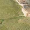
The remains of Forvie church lie isolated among the dunes of Forvie National Nature Reserve, some 1.8km ESE of Waterside farmsteading (NK02NW 38). The church measures 15.5m from E to W by 6.25m transversely within walls 0.8m in thickness and up to 2m in height, and there are opposed doorways in the N and S sides towards the W end. The N entrance measures 0.8m in width and retains rebated sandstone jambs at ground level on both sides of the opening. These offer a striking contrast to the inky-dark, metamorphic stone that has been employed elsewhere in the building. The S entrance retains only a single jamb on its W side. The only other feature of the walls is an aumbry at the NE corner of the church with an opening 0.7m square. The interior of the aumbry measures 0.38m in depth by 1.1m transversely, extending back behind the inner face of the wall to the W of the opening.
Within the interior, some 4.6m from the E end, a stone protrudes 0.15m above the ground. In view of the disturbance in this part of the church, it is not clear whether this stone marks the edge of a raised area of the floor at the E end.
Visited by RCAHMS (ATW, JRS), 31 January 1997.
NK 0204 2661 A watching brief was maintained in February 2003 while the footbridge crossing the Old Kirk Burn at Forvie Kirk was replaced and upgraded. No archaeological features or finds were evident.
Archive to be deposited in the NMRS.
Sponsor: SNH.
J C Murray 2003.
NK 0201 5658 In 2003, an archaeological watching brief was maintained while the bridge that crosses the Old Kirk Burn at Forvie Kirk was upgraded and replaced. As part of further upgrading work, the pathway immediately on either side of the bridge was renewed in February 2006. A watching brief was maintained whilst this work was undertaken. With the exception of the buried turf line on the E path, no archaeological features were evident during the course of the watching brief.
J C Murray 2006
NK 0204 2661. A watching brief was maintained on the 28th June 2007 during the placement of a number of 'finger' interpretative posts around the area of Forvie Kirk and deserted medieval village. In all 5 posts were placed, each post was 90mm square and reequired to be dug in to a depth of c.750mm. The holes were excavated by hand in short spits of c.200mm and were c.180mm square.
Post 1 - NK 01962 26600. No archaeological features or finds were evident.
Post 2 - NK 02015 26585. No archaeological features or finds were evident.
Post 3 and 3a - NK 02061 26613. Human remains.
Post 4 - NK 02088 26614. No archaeological features or finds were evident.
Post 5 - NK 01992 26560 . No archaeological features or finds were evident.
With the exceptionof the human remains evident in Post-holes 3 and 3a, no other archaeological features or finds were evident. It is now apparent, however, that a burial ground associated with the kirk is located to the S and W of the kirk.
Sponsor: Scottish Natural Heritage.
J C Murray, 2007.
Watching Brief (28 June 2007)
NK 0206 2661 A watching brief was undertaken on 28 June 2007 to observe the placement of interpretive posts around the ruins of Forvie medieval church. Human bone was found at the base of two postholes (each 90mm square), indicating the presence of the medieval cemetery to the S and W of the church.
The human remains were recorded but left in situ and the posts moved to a different area.
Reports deposited with Aberdeenshire SMR, Historic Scotland and RCAHMS.
Funder: Scottish Natural Heritage.
Standing Building Recording (6 August 2015)
NK 0204 2661 A Level 1 standing building survey was carried out on 6 August 2015 in support of a SAM consent application for repointing and repair of the structure. Plans and elevations were drawn and a photographic survey completed. Areas where walling required repair or stones had been removed
were highlighted.
Archive: National Record of the Historic Environment (NRHE)
Funder: Scottish Natural Heritage
Alison Cameron - Cameron Archaeology
(Source: DES, Volume 16)
Field Visit (October 2022)
NK 02071 26620 Visited during fieldwork by SCAPE. No changes to description.
Information from S. Boyd and J. Hambly - Scottish Coastal Archaeology and the Problem of Erosion (SCAPE).

