
Dumfries, Nunholm Road, Nith Viaduct


Railway Viaduct (19th Century)
Site Name Dumfries, Nunholm Road, Nith Viaduct
Classification Railway Viaduct (19th Century)
Alternative Name(s) Lincluden; River Nith
Canmore ID 208093
Site Number NX97NE 478
NGR NX 97140 77339
Datum OSGB36 - NGR
Permalink http://canmore.org.uk/site/208093


- Council Dumfries And Galloway
- Parish Dumfries
- Former Region Dumfries And Galloway
- Former District Nithsdale
- Former County Dumfries-shire
NX97NE 478 97125 77345
Location formerly cited as NX 97140 77339.
Not to be confused with Martinton Bridge (over River Nith at NX 97344 77846), for which see NX97NE 92.
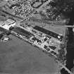
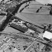
Nith Viaduct, 1859, by John Miller, junr, on the Castle Douglas line: five segmental arches, unusually sharply skewed.
J R Hume 2000.
This viaduct formerly carried the Dumfries - Stranraer 'Port Road' (which also formed the railway route into Galloway) across the River Nith to the NW of Dumfries and E of Lincluden. The river here forms the boundary between the parishes of Terregles (to the W) and Dumfries (to the E).
The location assigned to this record defines the midpoint of the structure. The available map evidence indicates that it extends from NX c. 97066 77338 to NX c. 97214 77345.
This viaduct is depicted, but not noted, on the 1991 edition of the OS 1:10,000 map.
Information from RCAHMS (RJCM), 17 March 2006.

