
Bogenjohn


Pit(S) (Period Unassigned), Ring Ditch(S) (Period Unassigned), Unenclosed Settlement (Period Unassigned)(Possible)
Site Name Bogenjohn
Classification Pit(S) (Period Unassigned), Ring Ditch(S) (Period Unassigned), Unenclosed Settlement (Period Unassigned)(Possible)
Canmore ID 20753
Site Number NJ95SW 18
NGR NJ 936 530
Datum OSGB36 - NGR
Permalink http://canmore.org.uk/site/20753


- Council Aberdeenshire
- Parish Strichen
- Former Region Grampian
- Former District Banff And Buchan
- Former County Aberdeenshire
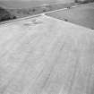
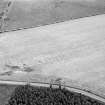
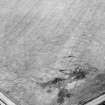
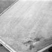
NJ95SW 18 936 530.
On a gentle NE-facing slope, the cropmark of a ring ditch with rectilinear, internal feature.
Sponsors: RCAHMS, Grampian Regional Council.
I Ralston 1991

