
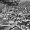
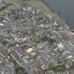
Largs, Promenade, General


Promenade (19th Century) - (20th Century)
Site Name Largs, Promenade, General
Classification Promenade (19th Century) - (20th Century)
Alternative Name(s) Esplanade
Canmore ID 207501
Site Number NS25NW 171
NGR NS 20123 59524
NGR Description From NS 20106 60113 to NS 20722 58031
Datum OSGB36 - NGR
Permalink http://canmore.org.uk/site/207501


- Council North Ayrshire
- Parish Largs
- Former Region Strathclyde
- Former District Cunninghame
- Former County Ayrshire
NMRS REFERENCE:
NS25NW 171.00 c. 20123 59524 Promenade
The promenade is also depicted on the mapsheet NS26SW.

