
Pricing Change
New pricing for orders of material from this site will come into place shortly. Charges for supply of digital images, digitisation on demand, prints and licensing will be altered.
Wormit, Wormit Hill, Tay Bridge, Inner Landward Defences


Building (First World War), Building (Period Unassigned), Trench(S) (First World War)
Site Name Wormit, Wormit Hill, Tay Bridge, Inner Landward Defences
Classification Building (First World War), Building (Period Unassigned), Trench(S) (First World War)
Canmore ID 207448
Site Number NO42NW 136
NGR NO 4003 2606
NGR Description NO c.4003 2606, NO c.4021 2620 and NO c.3977 2594
Datum OSGB36 - NGR
Permalink http://canmore.org.uk/site/207448


- Council Fife
- Parish Forgan
- Former Region Fife
- Former District North East Fife
- Former County Fife
A large-scale map dated 1916 on a War Department file (The National Archives WO 78/4417) shows a summary of the landward defences of Dundee (on the Angus side) and the Tay Railway Bridge (on the Fife side).
The southern approaches to the Tay Railway Bridge had two lines of defence. The inner defences comprised five 'defended posts', the nature of which is not clear, and one 'defended cottage'. Four of the posts and the cottage are in a line about 1200m long and about 350m from the southern end of the bridge. The fifth post was set about 650m to the east, at NO 412 266.
Information from HS/RCAHMS World War One Audit Project (GJB) 12 August 2013.
NO42NW 136 c.4003 2606, c.4021 2620 and c.3977 2594
See also Map sheet NO32NE
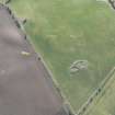
A possible searchlight battery has been identified from WW II RAF oblique and vertical air phtographs (S309, 41, flown 28 January 1942 and NLA 64, 5001-2, flown 1 June 1943 respectively) situated on the summit of Wormit Hill. Visible on the air photographs are three circular embanked enclosures with centrally placed installations within. It is unclear from the 1942 photograph exactly what the equipment is, but by their location and comparison with other similar installations it is likely they are searchlight platforms. The air photograph taken in 1943 reveals that the postions had been abandoned by this time as only the banked enclosures were visible.
Information from RCAHMS (DE), February 2002
Note (12 August 2013)
Previously recorded in error as a searchlight battery.
The site comprises three earthwork features previously identified on aerial imagery on the ridge of Wormit Hill. Each earthwork is roughly circular c. 14m in diameter with a short 'tail' or trench extending c. 6m to the NW arc. These would appear to be defensive positions.
The earthworks appear to match the large-scale map dated 1916 on a War Department file (The National Archives WO 78/4417) which shows five defended posts and one defended cottage to the south of the Tay Railway Bridge. The other positions are at
A building marked on the map as a defended cottage may be the building at NO 39534 25872.
Information from RCAHMS (AKK) 12 August 2013.
Project (March 2013 - September 2013)
A project to characterise the quantity and quality of the Scottish resource of known surviving remains of the First World War. Carried out in partnership between Historic Scotland and RCAHMS.

