
Ardrossan, South Crescent Road, St Peter-in-chains Roman Catholic Church


Church (Period Unassigned)
Site Name Ardrossan, South Crescent Road, St Peter-in-chains Roman Catholic Church
Classification Church (Period Unassigned)
Alternative Name(s) St Peter-ad-vincula
Canmore ID 205150
Site Number NS24SW 121
NGR NS 23292 42155
Datum OSGB36 - NGR
Permalink http://canmore.org.uk/site/205150
Ordnance Survey licence number AC0000807262. All rights reserved.
Canmore Disclaimer.
© Bluesky International Limited 2025. Public Sector Viewing Terms
- Correction
- Favourite

DP 005127
Detail of specimen station of the cross
Records of the Royal Commission on the Ancient and Historical Monuments of Scotland (RCAHMS), Edinbu
1/9/2005
© Crown Copyright: HES

DP 005128
Detail of specimen station of the cross
Records of the Royal Commission on the Ancient and Historical Monuments of Scotland (RCAHMS), Edinbu
1/9/2005
© Crown Copyright: HES

DP 005133
Records of the Royal Commission on the Ancient and Historical Monuments of Scotland (RCAHMS), Edinbu
1/9/2005
© Crown Copyright: HES

DP 005134
Records of the Royal Commission on the Ancient and Historical Monuments of Scotland (RCAHMS), Edinbu
1/9/2005
© Crown Copyright: HES

SC 1330210
View of halls from W
Records of the Royal Commission on the Ancient and Historical Monuments of Scotland (RCAHMS), Edinbu
1/9/2005
© Crown Copyright: HES

SC 1330213
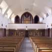
Interior. Sanctuary View from E showing gallery and organ
Records of the Royal Commission on the Ancient and Historical Monuments of Scotland (RCAHMS), Edinbu
1/9/2005
© Crown Copyright: HES

SC 1500618
General view from SSE
Records of the Royal Commission on the Ancient and Historical Monuments of Scotland (RCAHMS), Edinbu
© Crown Copyright: HES

SC 2532708
View from ESE
Records of the Royal Commission on the Ancient and Historical Monuments of Scotland (RCAHMS), Edinbu
© Crown Copyright: HES

SC 2532712
View from SW
Records of the Royal Commission on the Ancient and Historical Monuments of Scotland (RCAHMS), Edinbu
© Crown Copyright: HES

SC 2532844
View from W shoiwng railings and gate pier
Records of the Royal Commission on the Ancient and Historical Monuments of Scotland (RCAHMS), Edinbu
1/9/2005
© Crown Copyright: HES

SC 2532847
View from SW
Records of the Royal Commission on the Ancient and Historical Monuments of Scotland (RCAHMS), Edinbu
1/9/2005
© Crown Copyright: HES

SC 2532858
Interior. Sanctuary View from W
Records of the Royal Commission on the Ancient and Historical Monuments of Scotland (RCAHMS), Edinbu
1/9/2005
© Crown Copyright: HES

SC 1330196
View from W on axis
Records of the Royal Commission on the Ancient and Historical Monuments of Scotland (RCAHMS), Edinbu
1/9/2005
© Crown Copyright: HES

SC 1500620
View from W
Records of the Royal Commission on the Ancient and Historical Monuments of Scotland (RCAHMS), Edinbu
© Crown Copyright: HES

SC 2532710
View from SSW
Records of the Royal Commission on the Ancient and Historical Monuments of Scotland (RCAHMS), Edinbu
© Crown Copyright: HES

SC 2532839
View from WSW
Records of the Royal Commission on the Ancient and Historical Monuments of Scotland (RCAHMS), Edinbu
1/9/2005
© Crown Copyright: HES

SC 2532842
View from W on axis
Records of the Royal Commission on the Ancient and Historical Monuments of Scotland (RCAHMS), Edinbu
1/9/2005
© Crown Copyright: HES

SC 2532851
View from S church and war memorial
Records of the Royal Commission on the Ancient and Historical Monuments of Scotland (RCAHMS), Edinbu
1/9/2005
© Crown Copyright: HES

SC 2532855
View of halls from W
Records of the Royal Commission on the Ancient and Historical Monuments of Scotland (RCAHMS), Edinbu
1/9/2005
© Crown Copyright: HES

SC 2532868
Interior. View of halls entrance lobby
Records of the Royal Commission on the Ancient and Historical Monuments of Scotland (RCAHMS), Edinbu
1/9/2005
© Crown Copyright: HES

SC 2532871
Interior. View of hall
Records of the Royal Commission on the Ancient and Historical Monuments of Scotland (RCAHMS), Edinbu
1/9/2005
© Crown Copyright: HES

DP 005126
Interior. View from W
Records of the Royal Commission on the Ancient and Historical Monuments of Scotland (RCAHMS), Edinbu
1/9/2005
© Crown Copyright: HES

DP 005135
Records of the Royal Commission on the Ancient and Historical Monuments of Scotland (RCAHMS), Edinbu
1/9/2005
© Crown Copyright: HES

SC 1274190
View from WSW
Records of the Royal Commission on the Ancient and Historical Monuments of Scotland (RCAHMS), Edinbu
1/9/2005
© Crown Copyright: HES

SC 1330205
View from SW
Records of the Royal Commission on the Ancient and Historical Monuments of Scotland (RCAHMS), Edinbu
1/9/2005
© Crown Copyright: HES

SC 1330214
Interior. View of chancel from NW
Records of the Royal Commission on the Ancient and Historical Monuments of Scotland (RCAHMS), Edinbu
1/9/2005
© Crown Copyright: HES

SC 1330216
Interior. View of entrance lobby and gallery stairs
Records of the Royal Commission on the Ancient and Historical Monuments of Scotland (RCAHMS), Edinbu
1/9/2005
© Crown Copyright: HES

SC 2532707
General view from SSE
Records of the Royal Commission on the Ancient and Historical Monuments of Scotland (RCAHMS), Edinbu
© Crown Copyright: HES

SC 2532840
View from NW
Records of the Royal Commission on the Ancient and Historical Monuments of Scotland (RCAHMS), Edinbu
1/9/2005
© Crown Copyright: HES

SC 2532853
Detail of W door
Records of the Royal Commission on the Ancient and Historical Monuments of Scotland (RCAHMS), Edinbu
1/9/2005
© Crown Copyright: HES

SC 2532859
Interior. Sanctuary View from E showing gallery and organ
Records of the Royal Commission on the Ancient and Historical Monuments of Scotland (RCAHMS), Edinbu
1/9/2005
© Crown Copyright: HES

SC 2532860
Interior. View of chancel from NW
Records of the Royal Commission on the Ancient and Historical Monuments of Scotland (RCAHMS), Edinbu
1/9/2005
© Crown Copyright: HES

SC 2532861
Interior. View of chancel from NW
Records of the Royal Commission on the Ancient and Historical Monuments of Scotland (RCAHMS), Edinbu
1/9/2005
© Crown Copyright: HES

SC 2532862
Interior. View of chapel of the Blessed Sacrament
Records of the Royal Commission on the Ancient and Historical Monuments of Scotland (RCAHMS), Edinbu
1/9/2005
© Crown Copyright: HES

SC 2532865
Interior. View of entrance lobby and gallery stairs
Records of the Royal Commission on the Ancient and Historical Monuments of Scotland (RCAHMS), Edinbu
1/9/2005
© Crown Copyright: HES

DP 005132
Detail of canopy over altar
Records of the Royal Commission on the Ancient and Historical Monuments of Scotland (RCAHMS), Edinbu
1/9/2005
© Crown Copyright: HES

DP 031049
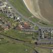
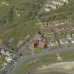
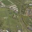
Oblique aerial view centred on the Church, taken from the NW.
RCAHMS Aerial Photography Digital
1/5/2007
© Crown Copyright: HES

DP 031053
Oblique aerial view centred the Church with the remains of Ardrossan Castle adjacent, taken from the SSW.
RCAHMS Aerial Photography Digital
1/5/2007
© Crown Copyright: HES

SC 1330203
View from W showing railings and gate pier
Records of the Royal Commission on the Ancient and Historical Monuments of Scotland (RCAHMS), Edinbu
1/9/2005
© Crown Copyright: HES

SC 1330217
Interior. Sanctuary View from E showing gallery and organ
Records of the Royal Commission on the Ancient and Historical Monuments of Scotland (RCAHMS), Edinbu
1/9/2005
© Crown Copyright: HES

SC 1330219
Interior. View of hall
Records of the Royal Commission on the Ancient and Historical Monuments of Scotland (RCAHMS), Edinbu
1/9/2005
© Crown Copyright: HES

SC 1500621
View from SSW
Records of the Royal Commission on the Ancient and Historical Monuments of Scotland (RCAHMS), Edinbu
© Crown Copyright: HES

SC 2532713
View from SW
Records of the Royal Commission on the Ancient and Historical Monuments of Scotland (RCAHMS), Edinbu
© Crown Copyright: HES

SC 2532838
View from NW
Records of the Royal Commission on the Ancient and Historical Monuments of Scotland (RCAHMS), Edinbu
1/9/2005
© Crown Copyright: HES

SC 2532857
Interior. Sanctuary View from W
Records of the Royal Commission on the Ancient and Historical Monuments of Scotland (RCAHMS), Edinbu
1/9/2005
© Crown Copyright: HES

SC 2532869
Interior. View of halls entrance lobby
Records of the Royal Commission on the Ancient and Historical Monuments of Scotland (RCAHMS), Edinbu
1/9/2005
© Crown Copyright: HES

DP 005129
Detail of specimen station of the cross
Records of the Royal Commission on the Ancient and Historical Monuments of Scotland (RCAHMS), Edinbu
1/9/2005
© Crown Copyright: HES

DP 005130
Detail of mosaic
Records of the Royal Commission on the Ancient and Historical Monuments of Scotland (RCAHMS), Edinbu
1/9/2005
© Crown Copyright: HES

DP 005131
Detail of chair
Records of the Royal Commission on the Ancient and Historical Monuments of Scotland (RCAHMS), Edinbu
1/9/2005
© Crown Copyright: HES

SC 1330208
View fromm SSE
Records of the Royal Commission on the Ancient and Historical Monuments of Scotland (RCAHMS), Edinbu
1/9/2005
© Crown Copyright: HES

SC 1330209
Detail of W door, St Peter-In-Chains Roman Catholic Church, Ardrossan.
Records of the Royal Commission on the Ancient and Historical Monuments of Scotland (RCAHMS), Edinbu
1/9/2005
© Crown Copyright: HES

SC 1330211
Interior. Sanctuary View from W
Records of the Royal Commission on the Ancient and Historical Monuments of Scotland (RCAHMS), Edinbu
1/9/2005
© Crown Copyright: HES

SC 2532848
View from SW
Records of the Royal Commission on the Ancient and Historical Monuments of Scotland (RCAHMS), Edinbu
1/9/2005
© Crown Copyright: HES

SC 2532849
View from SW
Records of the Royal Commission on the Ancient and Historical Monuments of Scotland (RCAHMS), Edinbu
1/9/2005
© Crown Copyright: HES

SC 2532850
View from S church and war memorial
Records of the Royal Commission on the Ancient and Historical Monuments of Scotland (RCAHMS), Edinbu
1/9/2005
© Crown Copyright: HES

SC 2532863
Interior. View of chapel of the Blessed Sacrament
Records of the Royal Commission on the Ancient and Historical Monuments of Scotland (RCAHMS), Edinbu
1/9/2005
© Crown Copyright: HES

SC 2532870
Interior. View of hall
Records of the Royal Commission on the Ancient and Historical Monuments of Scotland (RCAHMS), Edinbu
1/9/2005
© Crown Copyright: HES

SC 1330195
View from NW
Records of the Royal Commission on the Ancient and Historical Monuments of Scotland (RCAHMS), Edinbu
1/9/2005
© Crown Copyright: HES

SC 1500622
View from SW
Records of the Royal Commission on the Ancient and Historical Monuments of Scotland (RCAHMS), Edinbu
© Crown Copyright: HES

SC 2532706
General view from SSE
Records of the Royal Commission on the Ancient and Historical Monuments of Scotland (RCAHMS), Edinbu
© Crown Copyright: HES

SC 2532709
View from W
Records of the Royal Commission on the Ancient and Historical Monuments of Scotland (RCAHMS), Edinbu
© Crown Copyright: HES

SC 2532711
View from SSW
Records of the Royal Commission on the Ancient and Historical Monuments of Scotland (RCAHMS), Edinbu
© Crown Copyright: HES

SC 2532843
View from WSW
Records of the Royal Commission on the Ancient and Historical Monuments of Scotland (RCAHMS), Edinbu
1/9/2005
© Crown Copyright: HES

SC 2532845
View from W showing railings and gate pier
Records of the Royal Commission on the Ancient and Historical Monuments of Scotland (RCAHMS), Edinbu
1/9/2005
© Crown Copyright: HES

SC 2532856
View of halls from W
Records of the Royal Commission on the Ancient and Historical Monuments of Scotland (RCAHMS), Edinbu
1/9/2005
© Crown Copyright: HES

SC 2532864
Interior. View of entrance lobby and gallery stairs
Records of the Royal Commission on the Ancient and Historical Monuments of Scotland (RCAHMS), Edinbu
1/9/2005
© Crown Copyright: HES

SC 2532867
Interior. View of vestry
Records of the Royal Commission on the Ancient and Historical Monuments of Scotland (RCAHMS), Edinbu
1/9/2005
© Crown Copyright: HES

DP 031054
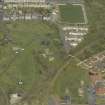
Oblique aerial view centred the Church with the remains of Ardrossan Castle adjacent, taken from the S.
RCAHMS Aerial Photography Digital
1/5/2007
© Crown Copyright: HES

SC 2532841
View from W on axis
Records of the Royal Commission on the Ancient and Historical Monuments of Scotland (RCAHMS), Edinbu
1/9/2005
© Crown Copyright: HES

SC 2532854
Detail of W door
Records of the Royal Commission on the Ancient and Historical Monuments of Scotland (RCAHMS), Edinbu
1/9/2005
© Crown Copyright: HES

SC 2532866
4Interior. View of vestry
Records of the Royal Commission on the Ancient and Historical Monuments of Scotland (RCAHMS), Edinbu
1/9/2005
© Crown Copyright: HES

DP 005125
Interior. View from E
Records of the Royal Commission on the Ancient and Historical Monuments of Scotland (RCAHMS), Edinbu
1/9/2005
© Crown Copyright: HES

DP 031050
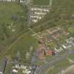
General oblique aerial view centred on the remains of Ardrossan Castle with the Monument and the Church adjacent, taken from the W.
RCAHMS Aerial Photography Digital
1/5/2007
© Crown Copyright: HES

DP 031051
Oblique aerial view centred on the Church, taken from the WSW.
RCAHMS Aerial Photography Digital
1/5/2007
© Crown Copyright: HES

DP 031052
Oblique aerial view centred on the remains of Ardrossan Castle with the Monument and Church adjacent, taken from the SW.
RCAHMS Aerial Photography Digital
1/5/2007
© Crown Copyright: HES

SC 1330206
View from SW
Records of the Royal Commission on the Ancient and Historical Monuments of Scotland (RCAHMS), Edinbu
1/9/2005
© Crown Copyright: HES

SC 1330215
Interior. View of chapel of the Blessed Sacrament
Records of the Royal Commission on the Ancient and Historical Monuments of Scotland (RCAHMS), Edinbu
1/9/2005
© Crown Copyright: HES

SC 1330218
Interior. View of halls entrance lobby
Records of the Royal Commission on the Ancient and Historical Monuments of Scotland (RCAHMS), Edinbu
1/9/2005
© Crown Copyright: HES

SC 1500619
View from ESE
Records of the Royal Commission on the Ancient and Historical Monuments of Scotland (RCAHMS), Edinbu
© Crown Copyright: HES

SC 2532846
View from SW
Records of the Royal Commission on the Ancient and Historical Monuments of Scotland (RCAHMS), Edinbu
1/9/2005
© Crown Copyright: HES

SC 2532852
View fromm SSE
Records of the Royal Commission on the Ancient and Historical Monuments of Scotland (RCAHMS), Edinbu
1/9/2005
© Crown Copyright: HES


- Council North Ayrshire
- Parish Ardrossan
- Former Region Strathclyde
- Former District Cunninghame
- Former County Ayrshire
NS24SW 121 23292 42155
St Peter in Chains R C Church [NAT]
OS (GIS) MasterMap, April 2010.
See also NS24SW 226.
Archaeological Evaluation (December 2002)
NS 23282 42233 A desk-based assessment and field evaluation were undertaken in December 2002 of a proposed development adjacent to the church of St Peter in Chains, within an area of prehistoric and medieval archaeological sites. The evaluation produced late medieval pottery within the fill of a late medieval ditch feature. A deposit of periwinkle shells overlying beach sands was also found, but was considered to be natural.
Archive to be deposited in the NMRS.
Sponsor: O'Brien Homes.
R Cachart 2004.

