
Monkland Canal, Coatbridge Cross Railway Bridge


Railway Bridge (19th Century)
Site Name Monkland Canal, Coatbridge Cross Railway Bridge
Classification Railway Bridge (19th Century)
Canmore ID 204575
Site Number NS76NW 68.03
NGR NS 73054 65087
Datum OSGB36 - NGR
Permalink http://canmore.org.uk/site/204575

- Council North Lanarkshire
- Parish Old Monkland (Monklands)
- Former Region Strathclyde
- Former District Monklands
- Former County Lanarkshire
NS76NW 68.03 73054 65087.
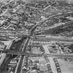
This bridge, in a lattice girder style, replaced the earlier dangerous level crossing on the road bridge (NS76NW 68.02). It conveyed the Monkland and Kirkintilloch Railway over the canal.
G Hutton 1993.
The NBR Hamilton Section line, which originally crossed on the road bridge (NS76NW 68.02) is clearly marked on the 2nd edition of the OS 6-inch map (Lanarkshire 1899, sheet viiSE) crossing the canal a little to the W of this road bridge. On plans in the North Lanarkshire Archives, Cumbernauld (Drumpellier Estate Papers U12 082 and U12 083) the bridge is still intact c.1900 and c.1905 and in the same archives (Monkland Photographic Collection) is a photograph, U6 1852, dated September 1990 showing the ironwork bridge with criss-cross pattern. The site is still visible on the current edition of the OS 1:10000 map (1982) and on the OS Basic Scale raster map (ND).
Information from RCAHMS (MD) 20 December 2001.

