
Mid Walls


Burial Ground (Medieval), Chapel (Medieval)
Site Name Mid Walls
Classification Burial Ground (Medieval), Chapel (Medieval)
Canmore ID 203
Site Number HU14NE 1
NGR HU 1983 4958
Datum OSGB36 - NGR
Permalink http://canmore.org.uk/site/203


- Council Shetland Islands
- Parish Walls And Sandness
- Former Region Shetland Islands Area
- Former District Shetland
- Former County Shetland
HU14NE 1 1983 4958.
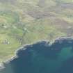
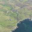
(HU 1981 4960) Chapel (NR) (Site of) Burial Ground (NR)
OS 6" map, Shetland, 2nd ed., (1903)
Allegedly the site of a pre-Reformation chapel, near the centre of an ancient burial ground.
Name Book 1878
The NW angle of the chapel comprising c.11.0m of the north wall and 4.3m of the west gable can still be distinguished on the ground as a course of earth-fast stones, the remainder having been washed away by the sea. The burial ground was enclosed by a stone wall, the footings of which can still be seen except on the south where erosion has destroyed it. The site is known locally but no further information was obtained.
Revised at 1/2500.
Visited by OS (WDJ) 12 June 1968

