
Greenock, Great Harbour, East Jetty


Jetty (19th Century)
Site Name Greenock, Great Harbour, East Jetty
Classification Jetty (19th Century)
Alternative Name(s) Garvel Embankment; Greenock Harbour
Canmore ID 202190
Site Number NS37NW 18.01
NGR NS 30085 75795
NGR Description Centred on NS 30085 75795
Datum OSGB36 - NGR
Permalink http://canmore.org.uk/site/202190


- Council Inverclyde
- Parish Greenock
- Former Region Strathclyde
- Former District Inverclyde
- Former County Renfrewshire
NS37NW 18.01 centred 30085 75795
For tanker cleaning installation and associated pier (centred NS 30400 75690), see NS37NW 18.02.
NS37NW 18.01 NS 30085 75795 (Centred on)
NS37NW 18.00 NS 30304 75600 Great Harbour
Note (6 June 2017)
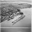
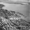
The East Jetty is an artificial island measuring about 870m in length from NW to SE by a maximum of 70m transversely which lies up to 230m off the souh bank of the River Clyde. The island is made up of spoil resulting from the excavation between 1878 and 1886 of the James Watt Dock (NS27NE 17.00). It is revetted all round by a battered stone wall and there is a slipway close to the NW end of the SW side. There is a navigation beacon at both ends of the island, the NW end of which is now linked to the shore by a road bridge which replaced a footbridge sometime after 1938. The 2nd edition of the OS 6-inch (Renfrewshire 1896, Sheets 002.06 and 002.07) depicts no buildings on the island and mooring posts only along the sheltered SW side, where there were timber ponds. Today the wider NW end of the island is effectively in use as an industrial unit whilst the SE end is largely unused or in disuse. A series of light vessels make use of the pontoons linked to the SW side of the island.
Information from HES, Survey and Recording (AKK) 2 April 2017.

