|
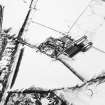
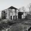
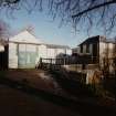
Photographs and Off-line Digital Images |
B 45971 |
|
Elevated view from NE showing W end of the works. |
15/2/1991 |
Item Level |
|
|
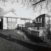
Photographs and Off-line Digital Images |
B 45972 |
|
View from SE showing W end of the works. |
15/2/1991 |
Item Level |
|
|
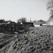
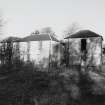
Photographs and Off-line Digital Images |
B 45973 |
|
View from S showing W end of the works. |
15/2/1991 |
Item Level |
|
|
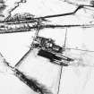
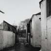
Photographs and Off-line Digital Images |
B 45974 |
|
View from W of yard at W end of the works. |
15/2/1991 |
Item Level |
|
|
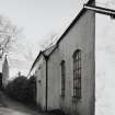
Photographs and Off-line Digital Images |
B 45975 |
|
View from SW of the NW wing of the works. |
15/2/1991 |
Item Level |
|
|
Photographs and Off-line Digital Images |
B 45976 |
|
View from SW. |
15/2/1991 |
Item Level |
|
|
Photographs and Off-line Digital Images |
B 45976 CN |
|
View from SW. |
15/2/1991 |
Item Level |
|
|
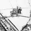
Photographs and Off-line Digital Images |
E 23550 |
RCAHMS Aerial Photography |
Oblique aerial view centred on the farmsteading with rig adjacent, taken from the SSW. |
5/2/2003 |
Item Level |
|
|
Photographs and Off-line Digital Images |
E 23551 |
RCAHMS Aerial Photography |
Oblique aerial view centred on the farmsteading with rig adjacent, taken from the SSE. |
5/2/2003 |
Item Level |
|
|
Photographs and Off-line Digital Images |
E 23552 |
RCAHMS Aerial Photography |
Oblique aerial view centred on the farmsteading with rig adjacent, taken from the ENE. |
5/2/2003 |
Item Level |
|
|
Manuscripts |
MS 2560/133 |
Scottish Farm Buildings Survey |
Annotated sketch plan |
25/5/2000 |
Item Level |
|
|
Manuscripts |
MS 2560/103 |
Records of the Royal Commission on the Ancient and Historical Monuments of Scotland (RCAHMS), Edinbu |
Draft index texts for the Scottish Farm Buildings Survey [early version], Area 6, West Central. This also includes site descriptions, extracts from documentary sources, and the analysis of farm building survey work (11pp). |
|
Item Level |
|
 |
On-line Digital Images |
SC 1724616 |
RCAHMS Aerial Photography |
Oblique aerial view centred on the farmsteading with rig adjacent, taken from the SSW. |
5/2/2003 |
Item Level |
|
 |
On-line Digital Images |
SC 1724617 |
RCAHMS Aerial Photography |
Oblique aerial view centred on the farmsteading with rig adjacent, taken from the SSE. |
5/2/2003 |
Item Level |
|
 |
On-line Digital Images |
SC 1724618 |
RCAHMS Aerial Photography |
Oblique aerial view centred on the farmsteading with rig adjacent, taken from the ENE. |
5/2/2003 |
Item Level |
|
 |
On-line Digital Images |
SC 2612851 |
|
Elevated view from NE showing W end of the works. |
15/2/1991 |
Item Level |
|
 |
On-line Digital Images |
SC 2612852 |
|
View from SE showing W end of the works. |
15/2/1991 |
Item Level |
|
 |
On-line Digital Images |
SC 2612853 |
|
View from S showing W end of the works. |
15/2/1991 |
Item Level |
|
 |
On-line Digital Images |
SC 2612854 |
|
View from W of yard at W end of the works. |
15/2/1991 |
Item Level |
|
 |
On-line Digital Images |
SC 2612855 |
|
View from SW of the NW wing of the works. |
15/2/1991 |
Item Level |
|
 |
On-line Digital Images |
SC 2612856 |
|
View from SW. |
15/2/1991 |
Item Level |
|
 |
On-line Digital Images |
SC 2612857 |
|
View from SW. |
15/2/1991 |
Item Level |
|
|
Manuscripts |
MS 2560/104 |
Records of the Royal Commission on the Ancient and Historical Monuments of Scotland (RCAHMS), Edinbu |
Text for the Scottish Farm Buildings Survey [final version], Area 6, West Central. This includes site descriptions, extracts from documentary sources, and the analysis of farm building survey work (4pp)
Tables showing agricultural output for Denny, Dunlop, Kilmaurs & Dunipace (4pp)
|
1/2/2000 |
Batch Level |
|


