
Dunlop, Hapland


Farmstead (Post Medieval), Rig And Furrow (Medieval) - (Post Medieval)
Site Name Dunlop, Hapland
Classification Farmstead (Post Medieval), Rig And Furrow (Medieval) - (Post Medieval)
Alternative Name(s) Ryeburn
Canmore ID 202038
Site Number NS44NW 63
NGR NS 4111 4985
Datum OSGB36 - NGR
Permalink http://canmore.org.uk/site/202038


- Council East Ayrshire
- Parish Dunlop
- Former Region Strathclyde
- Former District Kilmarnock And Loudoun
- Former County Ayrshire
Note (20 April 2004)
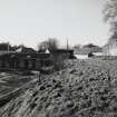
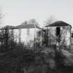
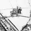
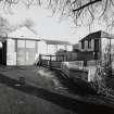
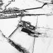
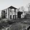
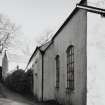
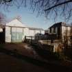
This farmsteading comprises a U-plan steading with the farmhouse on the southeastern side of a courtyard, the layout of which is shown on the OS 1:10,000 map (1970). To the NE of the steading there are some large barns and a circular open-top tank (RCAHMSAP2003). The ploughed-down earthworks of rig can be seen to the ENE of the farmsteading.
Information from RCAHMS (JB) 20 April 2004
Note (21 February 2006)
NS44NW 125 41161 49864
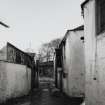
This farmstead has a U-shaped plan which incorporates, on the E side, the farmhouse and on the W three sheds. There are also several detached buildings including a corrugated-iron shed with a Belfast roof. The farmstead was visited in 2000.
Information from RCAHMS (SS), 21 February 2006.

