Accessibility

Font Size

100% 150% 200%

Background Colour

Default Contrast
Close Reset

Aberdeen, Leadside Road, Gilcomston Mills

Mill(S) (Period Unassigned)

Site Name Aberdeen, Leadside Road, Gilcomston Mills

Classification Mill(S) (Period Unassigned)

Canmore ID 20120

Site Number NJ90NW 210

NGR NJ 9333 0639

Datum OSGB36 - NGR

Permalink http://canmore.org.uk/site/20120

Ordnance Survey licence number AC0000807262. All rights reserved.
Canmore Disclaimer. © Bluesky International Limited 2025. Public Sector Viewing Terms

Toggle Aerial | View on large map

Digital Images

Aberdeen, Leadside Road, Gilcomston Mills
View of S frontage (Jack's Brae), from SE
Aberdeen, Leadside Road, Gilcomston Mills
View of S frontage (Jack's Brae), from SEAberdeen, Leadside Road, Gilcomston Mills, NJ90NW 210, Ordnance Survey index card, RectoAberdeen, Leadside Road, Gilcomston Mills
View of W gable and Jack's Brae frontage, from WAberdeen, Leadside Road, Gilcomston Mills.
General view from North-East showing Rosemount Square on right.Aberdeen, Leadside Road, Gilcomston Mills
View of frontage on Leadside Road, from EAberdeen, Leadside Road, Gilcomston Mills.
View from North-East.Aberdeen, Leadside Street, Gilcomston Mills.
General view from South-East.Aberdeen, Leadside Road, Gilcomston Mills.
General view from South.Aberdeen, Leadside Road, Gilcomston Mills
View of W gable and Leadside Road frontage, from WAberdeen, Leadside Road, Gilcomston Mills
General view of Leadside RoadAberdeen, Leadside Road, Gilcomston Mills.
General view from North-East showing Rosemount Square on right.Aberdeen, Leadside Road, Gilcomston Mills.
General view from North-West.

Administrative Areas

  • Council Aberdeen, City Of
  • Parish Aberdeen
  • Former Region Grampian
  • Former District City Of Aberdeen
  • Former County Aberdeenshire

Archaeology Notes

NJ90NW 210 9333 0639

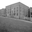
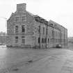
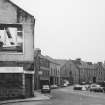
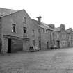
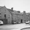
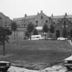
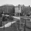
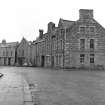
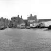
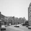
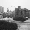
(Location cited as NJ 933 063). Gilcomston Mills (meal); Leadside Road. Built 18th-19th century. A two-storey and basement, 9-bay range with a single kiln, and a three-storey and attic, 5- by 6-bay block of later date. There are also two two-storey and attic store blocks. Originally water-powered, now electrically-driven.

J R Hume 1977.

(Location cited as NJ 933 063 and name as Leaside Road). Demolished in 1980's.

NMRS, MS/712/83.

References

MyCanmore Image Contributions


Contribute an Image

MyCanmore Text Contributions