
Aberdeen, Crabe Stone


Battle Site (16th Century), Battle Site (17th Century), Boundary Stone (Medieval)
Site Name Aberdeen, Crabe Stone
Classification Battle Site (16th Century), Battle Site (17th Century), Boundary Stone (Medieval)
Alternative Name(s) Craibstone; Craib Stone; Crab's Stone; Crabstone; Hardgate; 6 West Craibstone Street
Canmore ID 20119
Site Number NJ90NW 21
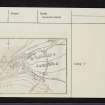
NGR NJ 93557 05786
Datum OSGB36 - NGR
Permalink http://canmore.org.uk/site/20119


- Council Aberdeen, City Of
- Parish Aberdeen
- Former Region Grampian
- Former District City Of Aberdeen
- Former County Aberdeenshire
NJ90NW 21 93557 05786.
(NJ 9355 0578) Crabe Stone. Site of Battles between the Forces of the Earl of Huntly and Lord Forbes AD 1571 and between Montrose and the Covenanters AD 1644. (NAT)
OS 1:500 map, Aberdeenshire, 1st ed. (1867).
Crabe Stone, Craibstone or Crab's Stone was a boundary stone of the lands of John Crab, who was baillie of Aberdeen in 1343. It was the site of a skirmish between the Forbeses and the Gordons on November 20th 1571, the Gordons being the victors; and the approximate site of an engagement on September 13th 1644 in which Montrose routed the Covenanters at the Justice Mills. (Justicemill Lane : NJ 934 057)
G M Fraser 1911; 1913; W Watt 1900
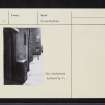
Crab or Crabe Stone is a roughly rectangular block of granite now built upon a brick foundation and situated against the wall of a building.
Visited by OS (JLD) 22 August 1952.
The battle fought on 13th Septmber 1644 was between a Covenanter force of 2,000 foot, 500 cavalry and some heavy artillery, defending the city of Aberdeen, who were opposed by around 1,500 foot and 75 horse led by the Marquis of Montrose. The latter was victorious.
M Brander 1975.
NJ 9355 0578. Stone, 'Crabstane'.
D I Harding 1997.
The Crabe or Craib Stone is a granite boulder, measuring 0.63m in breadth and 0.7m in height, which has been set into a modern wall about 1m above the level of the pavement; there is a commemorative plaque on the wall above the stone.
Visited by RCAHMS (JRS, ATW), 26 February 1997.

