
Pricing Change
New pricing for orders of material from this site will come into place shortly. Charges for supply of digital images, digitisation on demand, prints and licensing will be altered.
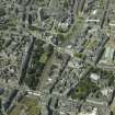
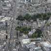
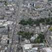
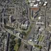
Aberdeen, 69-71 Schoolhill, East, South And West United Free Churches, General


Church(S) (19th Century)
Site Name Aberdeen, 69-71 Schoolhill, East, South And West United Free Churches, General
Classification Church(S) (19th Century)
Alternative Name(s) Triple Kirks; Three Churches; Albion And Saint Paul's Belmont Churches; High U. F. Church
Canmore ID 20080
Site Number NJ90NW 174
NGR NJ 93875 06307
NGR Description Centred on NJ 93875 06307
Datum OSGB36 - NGR
Permalink http://canmore.org.uk/site/20080


- Council Aberdeen, City Of
- Parish Aberdeen
- Former Region Grampian
- Former District City Of Aberdeen
- Former County Aberdeenshire
NJ90NW 174.00 Centred on NJ 93875 06307
See Architecture.
NJ90NW 174.01 NJ 93889 06308 Aberdeen, 69 Schoolhill, East and Belmont Church, now Public House.
NJ90NW 174.02 NJ 93883 06293 Aberdeen, 65 Belmont Street, Church Hall
NJ90NW 174.03 NJ 93869 06290 Aberdeen, 71 Schoolhill, Albion & St Paul's Church
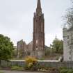
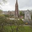
Built 1844, architect Archibald Simpson; alterations to East Church, William Kelly, 1900 and again 1965.
HBD List 1965.
Church, built 1844 by Archibald Simpson. Originally three Disruption churches ex St Nicholas grouped together. Early pointed, rubble with brick dressings; brick Marburg spire. Alterations to the E church by William Kelly in 1900 and again in 1965. The style is simple lancet gothic, brick being used to economise; the windows are Tudor Gothic. The ground floor walling is of squared granite rubble and above this the construction is of coarser random rubble with brick dressings to window and door openings; the stone dressings of tower and spire are of soft sandstone from Angus.
Part derelict, the rest converted to a restaurant and function rooms; threatened with demolition (1975).
(Additional bibliography cited).
NMRS, MS/712/83.
NMRS REFERENCE:
Schoolhill, East, South and West U.F Churches, 'Three Churches', 'Triple Kirks:
Three Churches grouped together to form a 'Z' plan on South side of Schoolhill between Denburn Road and Belmont Street. Erected after the Disruption of 1843.
Architect: Archibald Simpson, 1843-1844.
East U.F Church -
Became East and Belmont Church. Later Simpson's Restaurant. Currently 'Triple Kirks Bar'.
Opened, 1843.
See site: NJ90NW 174.01.
South U.F Church -
Became Halls and classroom for East U.F Church in 1890. Currently 'Dance Moves' dance studio.
See site: NJ90NW 174.02.
West U.F Church -
Was built to contain the congregation which broke away from the West Parish Church at the time of Disruption in 1843. Opened 1844.
Became known as High U.F Church. Later became Albion and St. Paul's Church.
Now demolished.
See site: NJ90NW 174.03.
EXTERNAL REFERENCE:
Aberdeen, Schoolhill, East, South and West U.F Churches.
Photographs: Aberdeen Public Library, Reference Dept: Slides: 1 - Arch. Simpson's Design for Churches.
Standing Building Recording (13 March 2012)
AOC Archaeology Group were commissioned by Stewart Milne Developments to undertake an historic building survey on the site of the former Triple Kirks, due to be partially demolished. The Triple Kirks buildings were constructed in 1843-4 to a design by architect Archibald Simpson as three churches created after a period of 'Disruption' in the nearby St Nicholas church, which caused the instigation of the creation of three new Free Churches. Built in the Early Pointed Gothic style, the three churches were built adjoining on one site in 7 months at a cost of around £5,300 and were largely built in granite rubble with brick dressings. In the 1960s, two of the churches and the tower and spire were left to deteriorate due to problems with dry rot and were eventually demolished (apart from the spire) in the 1990s. A Level 3 survey was undertaken of the building, which included an archive search, photographic, written and drawn record (annotation of architects' drawings).
Information from Oasis (aocarcha1-121411) 20 December 2013
Archaeological Evaluation (13 March 2012 - 22 March 2012)
NJ 9378 0627 An evaluation was undertaken 13–22 March 2012. Three test pits, each 2 x 2m, were excavated within the confines of the Triple Kirks and a single machine dug trench (30m2) excavated in the area between the N façade and the street frontage. All of the excavated areas contained the remains of walls and/or floors, some relating to the Triple Kirk structure and others predating the existing building. Finds of ceramic, animal bone, clay pipe and iron were recovered from various deposits in the test pits.
Archive: RCAHMS
Funder: Stewart Milne Developments
Lindsay Dunbar (AOC Archaeology Group) 2012 (DES)
Excavation (13 January 2014 - 23 January 2014)
AOC Archaeology Group was commissioned to undertake an archaeological excavation at the site of Triple Kirk, Aberdeen. This follows on from an Historic Building Recording and Archaeological Evaluation, both of which were carried out in early 2012. The excavation area, measuring 525 m2, was carried out within the footprint of the South Free Church. In the northern half of the excavation area the remains of surviving walls and foundations of the vestry of the South Free Church was recorded. In the southern half a number of walls, some of which were very poorly built, and other features, some of which are probably associated with early industrial
buildings depicted on a map from 1789.
Information from Alan Duffy (AOC), 29 January 2014
OASIS ID aocarcha1-169899

