
Following the launch of trove.scot in February 2025 we are now planning the retiral of some of our webservices. Canmore will be switched off on 24th June 2025. Information about the closure can be found on the HES website: Retiral of HES web services | Historic Environment Scotland
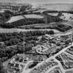
Aberdeen, Kettock Mills


Watermill (Period Unassigned)
Site Name Aberdeen, Kettock Mills
Classification Watermill (Period Unassigned)
Alternative Name(s) Kettock's Barley Mills; River Don
Canmore ID 20033
Site Number NJ90NW 131
NGR NJ 9356 0936
Datum OSGB36 - NGR
Permalink http://canmore.org.uk/site/20033


- Council Aberdeen, City Of
- Parish Old Machar
- Former Region Grampian
- Former District City Of Aberdeen
- Former County Aberdeenshire
NJ90NW 131.00 9356 0936
NJ90NW 131.01 NJ 9362 0904 to NJ 9360 0943 Mill lade; Weir
Kettock's Barley Mills [NAT]
OS 1:1250 map, 1978.
(Location cited as NJ 936 092). Kettock Mills (meal). Early 19th century. A large 3-storey and attic rubble building on an X plan, not now in production.
J R Hume 1977.

