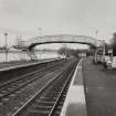
Accessibility

Font Size

100% 150% 200%

Background Colour

Default Contrast
Close Reset

Hartwood, Station

Railway Station (19th Century) - (20th Century)

Site Name Hartwood, Station

Classification Railway Station (19th Century) - (20th Century)

Canmore ID 200081

Site Number NS85NW 43

NGR NS 8484 5908

Datum OSGB36 - NGR

Permalink http://canmore.org.uk/site/200081

Ordnance Survey licence number AC0000807262. All rights reserved.
Canmore Disclaimer. © Bluesky International Limited 2025. Public Sector Viewing Terms

Toggle Aerial | View on large map

Digital Images

View of station platform and footbridge from W.
View of station platform and footbridge from W.General oblique aerial view of Hartwood village and former hospital, taken from the WSW.General oblique aerial view of Hartwood village and former hospital, taken from the WSW.

Administrative Areas

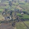
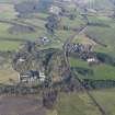
  • Council North Lanarkshire
  • Parish Shotts (Motherwell)
  • Former Region Strathclyde
  • Former District Motherwell
  • Former County Lanarkshire

References

MyCanmore Image Contributions


Contribute an Image

MyCanmore Text Contributions