
Glendorch


Farmstead (Period Unassigned), Field Boundary(S) (Period Unassigned), Rig And Furrow (Medieval) - (Post Medieval)
Site Name Glendorch
Classification Farmstead (Period Unassigned), Field Boundary(S) (Period Unassigned), Rig And Furrow (Medieval) - (Post Medieval)
Canmore ID 199554
Site Number NS81NE 22
NGR NS 87089 18878
Datum OSGB36 - NGR
Permalink http://canmore.org.uk/site/199554


- Council South Lanarkshire
- Parish Crawfordjohn
- Former Region Strathclyde
- Former District Clydesdale
- Former County Lanarkshire
NS81NE 22 87089 18878
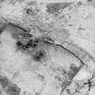
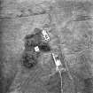
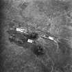
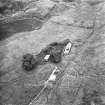
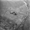
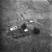
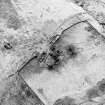
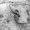
This farmstead, comprising two unroofed buildings, an enclosure and sheepfold, have been recorded on oblique aerial photography (RCAHMSAP 2000) at the junction between Sim's Burn and Glendorch Burn. A small area of rig and field banks sit immediately S of the sheepfold, and rig is visible within the walled enclosure to the N of the farmstead. The farmstead is depicted on the 1st edition of the OS 6-inch map (Lanarkshire 1864, sheet xlvi) as two roofed buildings, an enclosure and two sheepfolds, which are annoted 'Rees'. The remains of Glendorch tower-house (NS81NE 1) have been incorporated into the N building.
Information from RCAHMS (KMM) 16 April 2004.

