
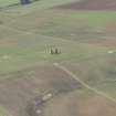
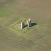
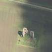
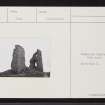
Fedderate Castle


Castle (Medieval), Tower House (Medieval)
Site Name Fedderate Castle
Classification Castle (Medieval), Tower House (Medieval)
Alternative Name(s) Federate
Canmore ID 19857
Site Number NJ84NE 1
NGR NJ 89688 49843
Datum OSGB36 - NGR
Permalink http://canmore.org.uk/site/19857


- Council Aberdeenshire
- Parish New Deer
- Former Region Grampian
- Former District Banff And Buchan
- Former County Aberdeenshire
NJ84NE 1 89688 49843
(NJ 8968 4984) Fedderate Castle (NR) (remains of)
OS 6" map, (1959).
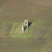
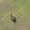
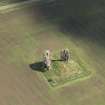
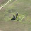
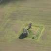
All that remains of Fedderate Castle is a portion of the walls, 30 feet high and 6 feet thick. It was surrounded partly by a ditch and partly by a morass now drained. A stone, removed from the castle c. 1830, now at Alehousehill, was dated 1257, thought to be the date of building.
Name Book 1871.
Fedderate Castle was formerly surrounded by a ditch and was reached by a causeway and drawbridge, traces of which were visible c.1790 (NSA 1845). The present remains are of an 'L' shaped building, 58' 8" x 44', probably late 15th century.
D MacGibbon and T Ross 1887-92.
The remains of an L-shaped tower-house, as described above, and known locally as Fedderate Castle. No trace of ditch or causeway remains. Revised at 1/2500.
Visited by OS (NKB) 22 April 1968.
Earth Resistance Survey (30 October 2010 - 31 October 2010)
NJ 89688 49843 The Old Statistical Account of Scotland describes Fedderate Castle as being defended partly by a marsh and partly by a moat. Access was by means of a causeway leading to a drawbridge. The moat and causeway have now completely disappeared and a geophysical survey was carried out on 30–31 October 2010 to try and locate them.
Magnetics was ineffective as the bedrock, probably at shallow depth, is the highly magnetic Maude gabbro.
Resistivity revealed a variety of linear features; some appear man-made, others were probably geological in origin. The most likely position for a causeway would appear to be on the NW side where a number of linear high resistance anomalies lead away from the castle. The most likely low resistance ‘moat’ anomaly is seen c20m to the NE of the castle. Given the slope on which the castle stands, any moat at this position would have to be very deep to hold water and it may be that the true moat was actually very close to the castle walls, where it would now be covered by rubble from the collapsed structure.
Archive: Aberdeenshire SMR (intended)
Funder: Aberdeenshire Council Archaeology Service
P Morris – Blairgowrie Geoscience

