
Pricing Change
New pricing for orders of material from this site will come into place shortly. Charges for supply of digital images, digitisation on demand, prints and licensing will be altered.
Clydebank, Duntocher, Roman Road, Trinity Parish Church


Church (20th Century), War Memorial (20th Century)
Site Name Clydebank, Duntocher, Roman Road, Trinity Parish Church
Classification Church (20th Century), War Memorial (20th Century)
Alternative Name(s) Church Of Scotland; Duntocher Parish Church; War Memorial
Canmore ID 197129
Site Number NS47SE 171
NGR NS 49425 72731
Datum OSGB36 - NGR
Permalink http://canmore.org.uk/site/197129
Ordnance Survey licence number AC0000807262. All rights reserved.
Canmore Disclaimer.
© Bluesky International Limited 2025. Public Sector Viewing Terms
- Correction
- Favourite

SC 1371910
View of hall from WNW
Records of the Royal Commission on the Ancient and Historical Monuments of Scotland (RCAHMS), Edinbu
4/5/2004
© Crown Copyright: HES

SC 1371923
Interior. Nave and passage aisle.
Records of the Royal Commission on the Ancient and Historical Monuments of Scotland (RCAHMS), Edinbu
4/5/2004
© Crown Copyright: HES

SC 1371925
Interior. Detail of brickwork and springing of arch
Records of the Royal Commission on the Ancient and Historical Monuments of Scotland (RCAHMS), Edinbu
4/5/2004
© Crown Copyright: HES

SC 1371930
Interior. Entrance lobby. Detail of WWI war memorial.
Records of the Royal Commission on the Ancient and Historical Monuments of Scotland (RCAHMS), Edinbu
4/5/2004
© Crown Copyright: HES

SC 2528407
Location view from ENE
Records of the Royal Commission on the Ancient and Historical Monuments of Scotland (RCAHMS), Edinbu
4/5/2004
© Crown Copyright: HES

SC 2528411
General view from SW
Records of the Royal Commission on the Ancient and Historical Monuments of Scotland (RCAHMS), Edinbu
4/5/2004
© Crown Copyright: HES

SC 2528413
View from NE
Records of the Royal Commission on the Ancient and Historical Monuments of Scotland (RCAHMS), Edinbu
4/5/2004
© Crown Copyright: HES

SC 2528435
Detail of plaque over hall entrance depicting tree and book
Records of the Royal Commission on the Ancient and Historical Monuments of Scotland (RCAHMS), Edinbu
4/5/2004
© Crown Copyright: HES

SC 2528436
Detail of main W entrance with inscription "1850-1931 Call thy walls salvation and thy gates praise Isaiah Chap 60 Verse 18"
Records of the Royal Commission on the Ancient and Historical Monuments of Scotland (RCAHMS), Edinbu
4/5/2004
© Crown Copyright: HES

SC 2528440
Interior. Chancel showing communion table and pulpit
Records of the Royal Commission on the Ancient and Historical Monuments of Scotland (RCAHMS), Edinbu
4/5/2004
© Crown Copyright: HES

SC 2528443
Interior. View of nave from gallery looking towards the communion table
Records of the Royal Commission on the Ancient and Historical Monuments of Scotland (RCAHMS), Edinbu
4/5/2004
© Crown Copyright: HES

SC 2528458
Interior. Entrance lobby. Detail of WWI war memorial.
Records of the Royal Commission on the Ancient and Historical Monuments of Scotland (RCAHMS), Edinbu
4/5/2004
© Crown Copyright: HES

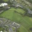
DP 020949
Oblique aerial view centred on the site of the Roman fort and Roman fortlet with the church adjacent, taken from the SE.
RCAHMS Aerial Photography Digital
8/9/2006
© Crown Copyright: HES

SC 1371908
View from S
Records of the Royal Commission on the Ancient and Historical Monuments of Scotland (RCAHMS), Edinbu
4/5/2004
© Crown Copyright: HES

SC 1371909
Detail of tower
Records of the Royal Commission on the Ancient and Historical Monuments of Scotland (RCAHMS), Edinbu
4/5/2004
© Crown Copyright: HES

SC 1371917
Detail of plaque over hall entrance depicting tree and book
Records of the Royal Commission on the Ancient and Historical Monuments of Scotland (RCAHMS), Edinbu
4/5/2004
© Crown Copyright: HES

SC 1371919
Interior. Nave looking towards the communion table
Records of the Royal Commission on the Ancient and Historical Monuments of Scotland (RCAHMS), Edinbu
4/5/2004
© Crown Copyright: HES

SC 2528428
View from SW
Records of the Royal Commission on the Ancient and Historical Monuments of Scotland (RCAHMS), Edinbu
4/5/2004
© Crown Copyright: HES

SC 2528441
Interior. Chancel showing communion table and pulpit
Records of the Royal Commission on the Ancient and Historical Monuments of Scotland (RCAHMS), Edinbu
4/5/2004
© Crown Copyright: HES

SC 2528445
Interior. Nave looking towards the gallery
Records of the Royal Commission on the Ancient and Historical Monuments of Scotland (RCAHMS), Edinbu
4/5/2004
© Crown Copyright: HES

SC 2528447
Interior. Nave and passage aisle.
Records of the Royal Commission on the Ancient and Historical Monuments of Scotland (RCAHMS), Edinbu
4/5/2004
© Crown Copyright: HES

SC 2528454
Interior. Entrance lobby
Records of the Royal Commission on the Ancient and Historical Monuments of Scotland (RCAHMS), Edinbu
4/5/2004
© Crown Copyright: HES

SC 1371901
General view from NE
Records of the Royal Commission on the Ancient and Historical Monuments of Scotland (RCAHMS), Edinbu
4/5/2004
© Crown Copyright: HES

SC 1371902
Location view from ENE
Records of the Royal Commission on the Ancient and Historical Monuments of Scotland (RCAHMS), Edinbu
4/5/2004
© Crown Copyright: HES

SC 1371904
General view from SW
Records of the Royal Commission on the Ancient and Historical Monuments of Scotland (RCAHMS), Edinbu
4/5/2004
© Crown Copyright: HES

SC 1371927
Interior. Entrance lobby
Records of the Royal Commission on the Ancient and Historical Monuments of Scotland (RCAHMS), Edinbu
4/5/2004
© Crown Copyright: HES

SC 1371931
Interior. Hall access corridor.
Records of the Royal Commission on the Ancient and Historical Monuments of Scotland (RCAHMS), Edinbu
4/5/2004
© Crown Copyright: HES


SC 2528406
General view from NE
Records of the Royal Commission on the Ancient and Historical Monuments of Scotland (RCAHMS), Edinbu
4/5/2004
© Crown Copyright: HES

SC 2528415
View rom NW
Records of the Royal Commission on the Ancient and Historical Monuments of Scotland (RCAHMS), Edinbu
4/5/2004
© Crown Copyright: HES

SC 2528416
View from NW
Records of the Royal Commission on the Ancient and Historical Monuments of Scotland (RCAHMS), Edinbu
4/5/2004
© Crown Copyright: HES

SC 2528417
General view from N including war memorial
Records of the Royal Commission on the Ancient and Historical Monuments of Scotland (RCAHMS), Edinbu
4/5/2004
© Crown Copyright: HES

SC 2528434
Detail of plaque over hall entrance depicting tree and book
Records of the Royal Commission on the Ancient and Historical Monuments of Scotland (RCAHMS), Edinbu
4/5/2004
© Crown Copyright: HES

SC 2528442
Interior. View of nave from gallery looking towards the communion table
Records of the Royal Commission on the Ancient and Historical Monuments of Scotland (RCAHMS), Edinbu
4/5/2004
© Crown Copyright: HES

SC 2528453
Interior. Entrance lobby
Records of the Royal Commission on the Ancient and Historical Monuments of Scotland (RCAHMS), Edinbu
4/5/2004
© Crown Copyright: HES

SC 1371905
View from NE
Records of the Royal Commission on the Ancient and Historical Monuments of Scotland (RCAHMS), Edinbu
4/5/2004
© Crown Copyright: HES

SC 1371914
Detail of tower entrance
Records of the Royal Commission on the Ancient and Historical Monuments of Scotland (RCAHMS), Edinbu
4/5/2004
© Crown Copyright: HES

SC 1371922
Interior. Nave looking towards the gallery
Records of the Royal Commission on the Ancient and Historical Monuments of Scotland (RCAHMS), Edinbu
4/5/2004
© Crown Copyright: HES

SC 1371924
Interior. SE Transept
Records of the Royal Commission on the Ancient and Historical Monuments of Scotland (RCAHMS), Edinbu
4/5/2004
© Crown Copyright: HES

SC 1371926
Interior. Detail of pulpit
Records of the Royal Commission on the Ancient and Historical Monuments of Scotland (RCAHMS), Edinbu
4/5/2004
© Crown Copyright: HES


SC 2528414
View from NE
Records of the Royal Commission on the Ancient and Historical Monuments of Scotland (RCAHMS), Edinbu
4/5/2004
© Crown Copyright: HES

SC 2528422
View of hall from WNW
Records of the Royal Commission on the Ancient and Historical Monuments of Scotland (RCAHMS), Edinbu
4/5/2004
© Crown Copyright: HES

SC 2528429
Detail of tower entrance
Records of the Royal Commission on the Ancient and Historical Monuments of Scotland (RCAHMS), Edinbu
4/5/2004
© Crown Copyright: HES

SC 2528438
Interior. Nave looking towards the communion table
Records of the Royal Commission on the Ancient and Historical Monuments of Scotland (RCAHMS), Edinbu
4/5/2004
© Crown Copyright: HES

SC 2528455
Interior. Entrance lobby. Gallery staircase
Records of the Royal Commission on the Ancient and Historical Monuments of Scotland (RCAHMS), Edinbu
4/5/2004
© Crown Copyright: HES

SC 2528459
Interior. Hall access corridor.
Records of the Royal Commission on the Ancient and Historical Monuments of Scotland (RCAHMS), Edinbu
4/5/2004
© Crown Copyright: HES

SC 1371907
General view from N including war memorial
Records of the Royal Commission on the Ancient and Historical Monuments of Scotland (RCAHMS), Edinbu
4/5/2004
© Crown Copyright: HES

SC 1371916
Detail of hall entrance
Records of the Royal Commission on the Ancient and Historical Monuments of Scotland (RCAHMS), Edinbu
4/5/2004
© Crown Copyright: HES

SC 1371918
Detail of main W entrance with inscription "1850-1931 Call thy walls salvation and thy gates praise Isaiah Chap 60 Verse 18"
Records of the Royal Commission on the Ancient and Historical Monuments of Scotland (RCAHMS), Edinbu
4/5/2004
© Crown Copyright: HES

SC 1371921
Interior. View of nave from gallery looking towards the communion table
Records of the Royal Commission on the Ancient and Historical Monuments of Scotland (RCAHMS), Edinbu
4/5/2004
© Crown Copyright: HES

SC 1371929
Interior. Entrance lobby. Doors to nave and decorativebrick panel
Records of the Royal Commission on the Ancient and Historical Monuments of Scotland (RCAHMS), Edinbu
4/5/2004
© Crown Copyright: HES

SC 2528423
View of hall from WNW
Records of the Royal Commission on the Ancient and Historical Monuments of Scotland (RCAHMS), Edinbu
4/5/2004
© Crown Copyright: HES

SC 2528430
Detail of hall entrance
Records of the Royal Commission on the Ancient and Historical Monuments of Scotland (RCAHMS), Edinbu
4/5/2004
© Crown Copyright: HES

SC 2528431
Detail of hall entrance
Records of the Royal Commission on the Ancient and Historical Monuments of Scotland (RCAHMS), Edinbu
4/5/2004
© Crown Copyright: HES

SC 2528448
Interior. SE Transept
Records of the Royal Commission on the Ancient and Historical Monuments of Scotland (RCAHMS), Edinbu
4/5/2004
© Crown Copyright: HES

SC 2528452
Interior. Detail of pulpit
Records of the Royal Commission on the Ancient and Historical Monuments of Scotland (RCAHMS), Edinbu
4/5/2004
© Crown Copyright: HES

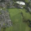
DP 018851
Oblique aerial view centred on the site of the Roman fort and Roman fortlet with the church adjacent, taken from the E.
RCAHMS Aerial Photography Digital
10/11/2006
© Crown Copyright: HES

SC 1371912
View from SE
Records of the Royal Commission on the Ancient and Historical Monuments of Scotland (RCAHMS), Edinbu
4/5/2004
© Crown Copyright: HES

SC 1371913
View from SW
Records of the Royal Commission on the Ancient and Historical Monuments of Scotland (RCAHMS), Edinbu
4/5/2004
© Crown Copyright: HES

SC 2528408
Location view from ENE
Records of the Royal Commission on the Ancient and Historical Monuments of Scotland (RCAHMS), Edinbu
4/5/2004
© Crown Copyright: HES

SC 2528409
General view from NW
Records of the Royal Commission on the Ancient and Historical Monuments of Scotland (RCAHMS), Edinbu
4/5/2004
© Crown Copyright: HES

SC 2528410
General view from NW
Records of the Royal Commission on the Ancient and Historical Monuments of Scotland (RCAHMS), Edinbu
4/5/2004
© Crown Copyright: HES

SC 2528420
View from S
Records of the Royal Commission on the Ancient and Historical Monuments of Scotland (RCAHMS), Edinbu
4/5/2004
© Crown Copyright: HES

SC 2528421
Detail of tower
Records of the Royal Commission on the Ancient and Historical Monuments of Scotland (RCAHMS), Edinbu
4/5/2004
© Crown Copyright: HES

SC 2528426
View from SE
Records of the Royal Commission on the Ancient and Historical Monuments of Scotland (RCAHMS), Edinbu
4/5/2004
© Crown Copyright: HES

SC 2528433
Detail of hall entrance
Records of the Royal Commission on the Ancient and Historical Monuments of Scotland (RCAHMS), Edinbu
4/5/2004
© Crown Copyright: HES

SC 2528450
Interior. Detail of brickwork and springing of arch
Records of the Royal Commission on the Ancient and Historical Monuments of Scotland (RCAHMS), Edinbu
4/5/2004
© Crown Copyright: HES

SC 2528460
Interior. Hall access corridor.
Records of the Royal Commission on the Ancient and Historical Monuments of Scotland (RCAHMS), Edinbu
4/5/2004
© Crown Copyright: HES

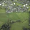
DP 020951
NNW oblique aerial view of Duntocher Roman Fort and Fortlet with adjacent Trinity Parish Church.
RCAHMS Aerial Photography Digital
8/9/2006
© Crown Copyright: HES

SC 1371903
General view from NW
Records of the Royal Commission on the Ancient and Historical Monuments of Scotland (RCAHMS), Edinbu
4/5/2004
© Crown Copyright: HES

SC 1371915
Detail of hall entrance
Records of the Royal Commission on the Ancient and Historical Monuments of Scotland (RCAHMS), Edinbu
4/5/2004
© Crown Copyright: HES

SC 2528418
General view from N including war memorial
Records of the Royal Commission on the Ancient and Historical Monuments of Scotland (RCAHMS), Edinbu
4/5/2004
© Crown Copyright: HES

SC 2528425
View from SE
Records of the Royal Commission on the Ancient and Historical Monuments of Scotland (RCAHMS), Edinbu
4/5/2004
© Crown Copyright: HES

SC 2528432
Detail of hall entrance
Records of the Royal Commission on the Ancient and Historical Monuments of Scotland (RCAHMS), Edinbu
4/5/2004
© Crown Copyright: HES

SC 2528437
Detail of main W entrance with inscription "1850-1931 Call thy walls salvation and thy gates praise Isaiah Chap 60 Verse 18"
Records of the Royal Commission on the Ancient and Historical Monuments of Scotland (RCAHMS), Edinbu
4/5/2004
© Crown Copyright: HES

SC 2528449
Interior. SE Transept
Records of the Royal Commission on the Ancient and Historical Monuments of Scotland (RCAHMS), Edinbu
4/5/2004
© Crown Copyright: HES

SC 2528451
Interior. Detail of pulpit
Records of the Royal Commission on the Ancient and Historical Monuments of Scotland (RCAHMS), Edinbu
4/5/2004
© Crown Copyright: HES

SC 2528456
Interior. Entrance lobby. Gallery staircase
Records of the Royal Commission on the Ancient and Historical Monuments of Scotland (RCAHMS), Edinbu
4/5/2004
© Crown Copyright: HES

SC 1371906
View from NW
Records of the Royal Commission on the Ancient and Historical Monuments of Scotland (RCAHMS), Edinbu
4/5/2004
© Crown Copyright: HES

SC 1371911
View of tower from NE
Records of the Royal Commission on the Ancient and Historical Monuments of Scotland (RCAHMS), Edinbu
4/5/2004
© Crown Copyright: HES

SC 1371920
Interior. Chancel showing communion table and pulpit
Records of the Royal Commission on the Ancient and Historical Monuments of Scotland (RCAHMS), Edinbu
4/5/2004
© Crown Copyright: HES

SC 1371928
Interior. Entrance lobby. Gallery staircase
Records of the Royal Commission on the Ancient and Historical Monuments of Scotland (RCAHMS), Edinbu
4/5/2004
© Crown Copyright: HES

SC 1371932
Interior. Hall.
Records of the Royal Commission on the Ancient and Historical Monuments of Scotland (RCAHMS), Edinbu
4/5/2004
© Crown Copyright: HES

SC 2528405
General view from NE
Records of the Royal Commission on the Ancient and Historical Monuments of Scotland (RCAHMS), Edinbu
4/5/2004
© Crown Copyright: HES

SC 2528412
General view from SW
Records of the Royal Commission on the Ancient and Historical Monuments of Scotland (RCAHMS), Edinbu
4/5/2004
© Crown Copyright: HES

SC 2528419
View from S
Records of the Royal Commission on the Ancient and Historical Monuments of Scotland (RCAHMS), Edinbu
4/5/2004
© Crown Copyright: HES

SC 2528424
View of tower from NE
Records of the Royal Commission on the Ancient and Historical Monuments of Scotland (RCAHMS), Edinbu
4/5/2004
© Crown Copyright: HES

SC 2528427
View from SW
Records of the Royal Commission on the Ancient and Historical Monuments of Scotland (RCAHMS), Edinbu
4/5/2004
© Crown Copyright: HES

SC 2528439
Interior. Nave looking towards the communion table
Records of the Royal Commission on the Ancient and Historical Monuments of Scotland (RCAHMS), Edinbu
4/5/2004
© Crown Copyright: HES

SC 2528444
Interior. Nave looking towards the gallery
Records of the Royal Commission on the Ancient and Historical Monuments of Scotland (RCAHMS), Edinbu
4/5/2004
© Crown Copyright: HES

SC 2528446
Interior. Nave and passage aisle.
Records of the Royal Commission on the Ancient and Historical Monuments of Scotland (RCAHMS), Edinbu
4/5/2004
© Crown Copyright: HES

SC 2528457
Interior. Entrance lobby. Doors to nave and decorativebrick panel
Records of the Royal Commission on the Ancient and Historical Monuments of Scotland (RCAHMS), Edinbu
4/5/2004
© Crown Copyright: HES

SC 2528461
Interior. Hall.
Records of the Royal Commission on the Ancient and Historical Monuments of Scotland (RCAHMS), Edinbu
4/5/2004
© Crown Copyright: HES


- Council West Dunbartonshire
- Parish Old Kilpatrick (Clydebank)
- Former Region Strathclyde
- Former District Clydebank
- Former County Dunbartonshire
NMRS REFERENCE
NS47SE 171.01 49403 72697 Duntocher, Trinity Parish Church, Manse
Watching Brief (2 November 2004 - 11 November 2004)
NS 4940 7273 A watching brief was required in November 2004 during the construction of an access ramp and underpinning of the tower at Duntocher Trinity Church (NS47SE 171), as the church lies adjacent to the site of a Roman fort and fortlet. No archaeologically significant features or artefacts were identified.
Archive to be deposited in the NMRS.
Sponsor: Duntocher Trinity Parish Church.
Martin Cook 2004
Note (22 January 2025)
A church is depicted on the 1st edition of the OS 25-inch map (1862) - Dumbartonshire XXIII.10 (with extension XXIII.11) (Old Kilpatrick). An extension to this church is depicted on the 2nd edition of the OS 25-inch map (1898) - Dumbartonshire XXIII.10. A further extension to this church digitised from orthoimagery provided by © Bluesky International Limited and Getmapping Limited 1999-2023. OS 1km map square NS4972 flown on 3 April 2021.
Information from HES (D Watson) 22 January 2025

