
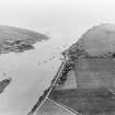
Montrose, Ferryden, Old Pier


Pier (Period Unassigned)
Site Name Montrose, Ferryden, Old Pier
Classification Pier (Period Unassigned)
Alternative Name(s) Port Of Montrose; Montrose, Harbour; River South Esk; Inchcape Quay; Brownlow Place; Nicoll's Knuckle; Rossie Island
Canmore ID 197014
Site Number NO75NW 144.01
NGR NO 7163 5673
Datum OSGB36 - NGR
Permalink http://canmore.org.uk/site/197014

- Council Angus
- Parish Craig
- Former Region Tayside
- Former District Angus
- Former County Angus

