
Shelden


Stone Circle (Neolithic) - (Bronze Age)
Site Name Shelden
Classification Stone Circle (Neolithic) - (Bronze Age)
Alternative Name(s) Sheldon Of Bourtie; Sheldon Stone Circle
Canmore ID 19697
Site Number NJ82SW 1
NGR NJ 8229 2493
Datum OSGB36 - NGR
Permalink http://canmore.org.uk/site/19697


- Council Aberdeenshire
- Parish Bourtie
- Former Region Grampian
- Former District Gordon
- Former County Aberdeenshire
NJ82SW 1 8229 2493.
(NJ 8229 2493) Stone Circle (NR) (Remains of) :
Cist found AD 1820 (TI). (NJ 8232 2492)
Human Remains found AD 1820 (NAT)
OS 6" map, Aberdeenshire, 2nd ed., (1928)
'It is said that much larger blocks of stone were cut up and carried away ...' In the same place was a large cairn, most of which was removed, in one part of which was found, about 1820, a stone coffin about 3 to 4 feet long, containing 'ashes and unctuous matter'. Human remains have also been found about 10 yards east of the circle.
Name Book 1867.
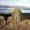
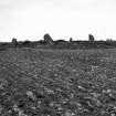
The stone circle at Shelden consists of six stones, between 5 and 6 feet high, and a seventh stone 8 feet 2 inches high, arranged in a 'broad oval'. There are another nine flat stones scattered around the circle. The interior of the circle is stony but shows no signs of a cairn.
F R Coles 1902.
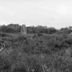
The seven upright stones described by Coles (1902) are surrounded by a low modern stone wall; the area enclosed has been used as a dump for stones from field clearance, so that it is impossible to separate the "nine flat stones" from more recent deposits.
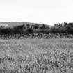
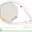
The five western standing stones are of similar size and shape and form a circle 23.2m in diameter. The modern wall runs along the western circumference of this circle and a low overgrown ridge of stones can just be traced on the east. The circle probably enclosed the large cairn mentioned by the Ordnance Survey Name Book (ONB) (1867).
A much larger stone stands just to the north of the circle, and 17.7m to the SE is a stone similar in size to those in the circle but triangular in shape.
Revised at 1/2500.
Visited by OS (NKB) 5 March 1964.
(Name cited as Sheldon Stone Circle). This stone circle is situated on a knoll at an altitude of 180m OD, and commands a view in all directions.
NMRS, MS/712/81.
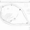
Measured Survey (29 April 1999)
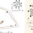
RCAHMS surveyed Sheldon stone circle on 29 April 1999 with plane table and alidade producing a plan and section at a scale of 1:100. The survey drawing was checked on-site on 30 March 2000. The plan and sections were used as the basis for an illustration, produced in ink and finished in vector graphics software, that was published at a scale of 1:250 (Welfare 2011, 541).
Publication Account (2011)
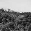
This stone circle, which has a two-stone alignment standing immediately to its east, is situated within a lenticular enclosure on the summit of a low hill 180m north of Sheldon. Now reduced to only five orthostats, the circle measures 24m in diameter and may have comprised as many as thirteen or fourteen stones if the rough spacing of the two on the south-east was maintained throughout the circumference. As far as can be detected with so many stones missing, the orthostats are not graded in height and range from 1.75m on the north-west (5) and south-west (1) to 1.7m on the south-south-east (2), 1.6m on the north-north-east (4) and 1.5m on the east-south-east (3). Indeed the tallest of the stones on this hilltop is the northern pillar in the alignment (A); this stands 2.2m high, while its pair (B) is 1.7m high. In 1867 the OS surveyors were told that ‘much larger blocks were cut up and carried away for building purposes’ (Name Book, Aberdeenshire, No. 10, p 48). The interior of the circle is disfigured with dumps of field clearance, but some of the stones visible between orthostats 1 and 2 on the south-east are quite firmly embedded and are possibly the remains of the cairn that was removed about 1820 to provide stones to build dykes and drains; in the course of the demolition a cist containing ‘ashes and unctuous matter’ was discovered (Name Book, Aberdeenshire, No. 10, pp 43, 48), while in the same year other human remains were found outside the circle to the south-east of the alignment (ibid p 48). Traces of rigs are also visible within the interior of the circle, showing that it had been taken into an arable field after the cairn was robbed. The enclosure, which hugs the west half of the circle and only diverges from this line to embrace the two stones of the alignment, was presumably constructed to protect the circle from any further damage. By the end of the 19th century the enclosure had descended into a chaos of gorse and whins, graphically revealed by a series of three photographs taken by James Ritchie in July 1902 (RCAHMS AB2510, AB2551 & AB2653). Under the circumstances, it is hardly surprising that Coles had struggled to record the remains the previous September, conflating the circle and the alignment into a single oval arrangement, and compounding any inaccuracies in his measurements by reversing the north point on his plan (1902, 512–13). As a result, he does not appear to have considered the possibility that this might have been a recumbent stone circle. This was left to Alexander Keiller (1934, 6), though he too was confused by the ring's orientation of the circle and placed the southern stone of the alignment (B) on the south-west rather than the south-east. Indeed, Barnatt is the first person to realise that there was not just one outlier here, but two (1989, 300, no. 6:84) – a much simpler explanation of the disposition of the stones than Alexander Thom’s attempt to construct two concentric circles with an overall diameter of over 30m and a single outlier on the south-east (Thom 1967, 59, fig 6.4; Thom et al 1980, 166–7). Nevertheless, most researchers have followed Keiller in listing Sheldon as a possible recumbent stone circle and accepting Thom’s diameter (Burl 1976a, 353, Abn 94; 2000, 422, Abn 96; Ruggles 1984, 60; 1999, 187, no. 60). While there is no doubt that this was a stone circle enclosing a cairn, the oblique reference by the OS surveyors in 1867 to ‘much larger blocks’ does not constitute evidence that there was once a recumbent here. If anything, the absence of any clear grading tends to argue against this being a recumbent stone circle, and it is best considered as one of the growing number of circles enclosing cairns where there was no recumbent setting.

