
Pricing Change
New pricing for orders of material from this site will come into place shortly. Charges for supply of digital images, digitisation on demand, prints and licensing will be altered.
House Of The Binns, Cottages And Stable Buildings


Stable(S) (19th Century)
Site Name House Of The Binns, Cottages And Stable Buildings
Classification Stable(S) (19th Century)
Alternative Name(s) The House Of The Binns; The Binns; Binns Policies
Canmore ID 195752
Site Number NT07NE 4.02
NGR NT 05029 78267
Datum OSGB36 - NGR
Permalink http://canmore.org.uk/site/195752


- Council West Lothian
- Parish Abercorn (West Lothian)
- Former Region Lothian
- Former District West Lothian
- Former County West Lothian
NT07NE 4.02 05029 78267
NMRS REFERENCE:
Plans:
Dick Peddie & MacKay, Edinburgh new cottages at stables
Bin 12, Bag 2 Peddie & Forbes Smith 1914
(Undated) information in NMRS.
Standing Building Recording (16 June 2013 - 24 June 2013)
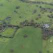
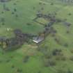
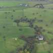
NT 05029 78067 A desk-based assessment and Level 3 standing building survey were carried out in June 2013 on the Stables Complex on the House of the Binns estate. The complex consisted of three ranges in a U-shaped formation surrounding a courtyard and fronted by an ornate central facade facing towards the E gate of the estate. The three ranges are mainly built of random rubble using basalt with sandstone quoins at the returns, which are noticeably of finer finish on the front, E face. The E face of the complex contains a central facade with a crenelated pitched profile and is decorated with two occuli and includes a segmented arch entrance into a central carriage house. The E-facing gables of the flanking ranges feature decorative blind arches. The interior of the complex is largely empty and heavily overgrown. The interior W-facing elevation of the N range features three in situ fireplaces. One fireplace is located on the first floor level indicating that a living or working space existed in the loft. The overall condition of the complex is poor.
Archive and report: RCAHMS (intended)
Funder: The National Trust for Scotland
Mike Cressey and Stuart Mitchell, CFA Archaeology Ltd, 2013
(Source: DES)
Reference (March 2013)
A complex of buildings arranged around a courtyard, located to the south-west of the walled garden, which are now ruinous. The layout comprises single storey buildings around three sides of a courtyard with a wall enclosing the fourth east side, at the centre of which is a building with arched entrance. The east wall is all crenulated, with the crenulations taken up the pitch of the pierced central gable forming a prominent feature. The design repeats the features of the archway to the courtyard on the east side of the House. While the designer for the farm building is not recorded, the close similarity to William Burn’s additions to the house suggests Burn as the architect.
The basic courtyard shape appears on Thomson’s 1818 map annotated ‘Office’. The 1:2500 1st edition OS map shows the courtyard of buildings with a circular feature in the courtyard, and a P-shaped building to its west. The 1896 OS shows a similar plan with different sub-divisions around it and a smaller building on the west. Today the courtyard of buildings are frequently referred to as ‘Barns’ or ‘Steadings’. Their use for stabling horses of the Scots Greys has been described in some documents although on what occasions is not stated.
A courtyard of buildings located south of the house is shown also on Roy’s map, although the distance from the house appears different to the present relationship, although other discrepancies in the depiction of the Binns are occur on the map.
Information from NTS (SCS) March 2013

